You are here: Home > Network List > IW - Intermountain West Stations List
> Station MOOW Moose Ponds, Wyoming, USA > Earthquake Result Viewer
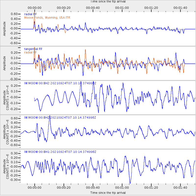
MOOW Moose Ponds, Wyoming, USA - Earthquake Result Viewer
*The percent match for this event was below the threshold and hence no stack was calculated.
| Earthquake location: |
Andreanof Islands, Aleutian Is. |
| Earthquake latitude/longitude: |
51.1/-179.0 |
| Earthquake time(UTC): |
2021/09/24 (267) 07:02:28 GMT |
| Earthquake Depth: |
18 km |
| Earthquake Magnitude: |
5.5 Mww |
| Earthquake Catalog/Contributor: |
NEIC PDE/us |
|
| Network: |
IW Intermountain West |
| Station: |
MOOW Moose Ponds, Wyoming, USA |
| Lat/Lon: |
43.75 N/110.74 W |
| Elevation: |
2128 m |
|
| Distance: |
45.2 deg |
| Az: |
71.45 deg |
| Baz: |
304.494 deg |
| Ray Param: |
$rayparam |
*The percent match for this event was below the threshold and hence was not used in the summary stack. |
|
| Radial Match: |
58.541187 % |
| Radial Bump: |
400 |
| Transverse Match: |
59.404076 % |
| Transverse Bump: |
400 |
| SOD ConfigId: |
26497111 |
| Insert Time: |
2021-10-21 18:02:31.922 +0000 |
| GWidth: |
2.5 |
| Max Bumps: |
400 |
| Tol: |
0.001 |
|
Signal To Noise
| Channel | StoN | STA | LTA |
| IW:MOOW:00:BHZ:20210924T07:10:14.374998Z | 1.5628659 | 1.982203E-7 | 1.2683131E-7 |
| IW:MOOW:00:BH1:20210924T07:10:14.374998Z | 1.1993824 | 8.6138265E-8 | 7.1818846E-8 |
| IW:MOOW:00:BH2:20210924T07:10:14.374998Z | 1.6507872 | 1.3366918E-7 | 8.0972995E-8 |
| Arrivals |
| Ps | |
| PpPs | |
| PsPs/PpSs | |


