You are here: Home > Network List > NM - Cooperative New Madrid Seismic Network Stations List
> Station HENM Henderson Mound,MO > Earthquake Result Viewer
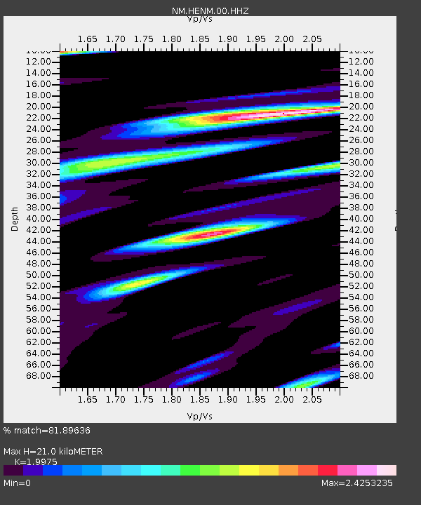
HENM Henderson Mound,MO - Earthquake Result Viewer
| Earthquake location: |
Andreanof Islands, Aleutian Is. |
| Earthquake latitude/longitude: |
51.1/-179.0 |
| Earthquake time(UTC): |
2021/09/24 (267) 07:02:28 GMT |
| Earthquake Depth: |
18 km |
| Earthquake Magnitude: |
5.5 Mww |
| Earthquake Catalog/Contributor: |
NEIC PDE/us |
|
| Network: |
NM Cooperative New Madrid Seismic Network |
| Station: |
HENM Henderson Mound,MO |
| Lat/Lon: |
36.72 N/89.47 W |
| Elevation: |
88 m |
|
| Distance: |
62.2 deg |
| Az: |
65.26 deg |
| Baz: |
314.594 deg |
| Ray Param: |
0.06036018 |
| Estimated Moho Depth: |
21.0 km |
| Estimated Crust Vp/Vs: |
2.00 |
| Assumed Crust Vp: |
6.444 km/s |
| Estimated Crust Vs: |
3.226 km/s |
| Estimated Crust Poisson's Ratio: |
0.33 |
|
| Radial Match: |
81.89636 % |
| Radial Bump: |
400 |
| Transverse Match: |
41.371586 % |
| Transverse Bump: |
363 |
| SOD ConfigId: |
26497111 |
| Insert Time: |
2021-10-21 18:06:42.472 +0000 |
| GWidth: |
2.5 |
| Max Bumps: |
400 |
| Tol: |
0.001 |
|

Signal To Noise
| Channel | StoN | STA | LTA |
| NM:HENM:00:HHZ:20210924T07:12:18.329984Z | 5.1137943 | 9.629655E-7 | 1.8830742E-7 |
| NM:HENM:00:HHN:20210924T07:12:18.329984Z | 1.6864024 | 6.291618E-7 | 3.7307925E-7 |
| NM:HENM:00:HHE:20210924T07:12:18.329984Z | 2.048667 | 8.9414317E-7 | 4.3645122E-7 |
| Arrivals |
| Ps | 3.4 SECOND |
| PpPs | 9.4 SECOND |
| PsPs/PpSs | 13 SECOND |


