You are here: Home > Network List > US - United States National Seismic Network Stations List
> Station AMTX Amarillo, Texas, USA > Earthquake Result Viewer
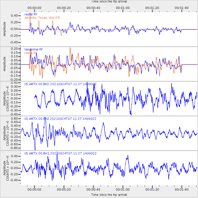
AMTX Amarillo, Texas, USA - Earthquake Result Viewer
*The percent match for this event was below the threshold and hence no stack was calculated.
| Earthquake location: |
Andreanof Islands, Aleutian Is. |
| Earthquake latitude/longitude: |
51.1/-179.0 |
| Earthquake time(UTC): |
2021/09/24 (267) 07:02:28 GMT |
| Earthquake Depth: |
18 km |
| Earthquake Magnitude: |
5.5 Mww |
| Earthquake Catalog/Contributor: |
NEIC PDE/us |
|
| Network: |
US United States National Seismic Network |
| Station: |
AMTX Amarillo, Texas, USA |
| Lat/Lon: |
34.53 N/101.41 W |
| Elevation: |
1010 m |
|
| Distance: |
56.7 deg |
| Az: |
74.867 deg |
| Baz: |
312.554 deg |
| Ray Param: |
$rayparam |
*The percent match for this event was below the threshold and hence was not used in the summary stack. |
|
| Radial Match: |
55.656296 % |
| Radial Bump: |
400 |
| Transverse Match: |
50.82551 % |
| Transverse Bump: |
400 |
| SOD ConfigId: |
26497111 |
| Insert Time: |
2021-10-21 18:15:02.460 +0000 |
| GWidth: |
2.5 |
| Max Bumps: |
400 |
| Tol: |
0.001 |
|
Signal To Noise
| Channel | StoN | STA | LTA |
| US:AMTX:00:BHZ:20210924T07:11:37.149992Z | 3.8776336 | 3.7690208E-7 | 9.7199E-8 |
| US:AMTX:00:BH1:20210924T07:11:37.149992Z | 1.8031197 | 1.4592018E-7 | 8.092651E-8 |
| US:AMTX:00:BH2:20210924T07:11:37.149992Z | 1.1843357 | 1.5425401E-7 | 1.3024517E-7 |
| Arrivals |
| Ps | |
| PpPs | |
| PsPs/PpSs | |


