You are here: Home > Network List > GS - US Geological Survey Networks Stations List
> Station KAN13 Rinehart Farm > Earthquake Result Viewer
KAN13 Rinehart Farm - Earthquake Result Viewer
*The percent match for this event was below the threshold and hence no stack was calculated.
| Earthquake location: |
Kuril Islands |
| Earthquake latitude/longitude: |
45.3/150.3 |
| Earthquake time(UTC): |
2018/03/18 (077) 18:00:10 GMT |
| Earthquake Depth: |
72 km |
| Earthquake Magnitude: |
5.1 Mww |
| Earthquake Catalog/Contributor: |
NEIC PDE/us |
|
| Network: |
GS US Geological Survey Networks |
| Station: |
KAN13 Rinehart Farm |
| Lat/Lon: |
37.01 N/97.48 W |
| Elevation: |
340 m |
|
| Distance: |
77.8 deg |
| Az: |
49.294 deg |
| Baz: |
318.083 deg |
| Ray Param: |
$rayparam |
*The percent match for this event was below the threshold and hence was not used in the summary stack. |
|
| Radial Match: |
48.34137 % |
| Radial Bump: |
400 |
| Transverse Match: |
31.958874 % |
| Transverse Bump: |
400 |
| SOD ConfigId: |
2643891 |
| Insert Time: |
2018-04-16 16:15:32.769 +0000 |
| GWidth: |
2.5 |
| Max Bumps: |
400 |
| Tol: |
0.001 |
|
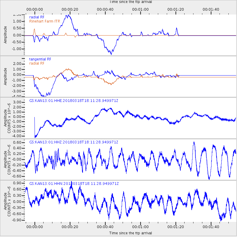
Signal To Noise
| Channel | StoN | STA | LTA |
| GS:KAN13:01:HHZ:20180318T18:11:28.949971Z | 1.6473751 | 2.7668912E-7 | 1.6795757E-7 |
| GS:KAN13:01:HHN:20180318T18:11:28.949971Z | 0.95580304 | 1.1995851E-6 | 1.2550547E-6 |
| GS:KAN13:01:HHE:20180318T18:11:28.949971Z | 0.8566609 | 8.797623E-7 | 1.0269669E-6 |
| Arrivals |
| Ps | |
| PpPs | |
| PsPs/PpSs | |


