You are here: Home > Network List > US - United States National Seismic Network Stations List
> Station MSO Missoula, Montana, USA > Earthquake Result Viewer
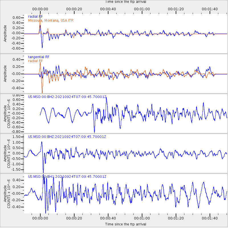
MSO Missoula, Montana, USA - Earthquake Result Viewer
*The percent match for this event was below the threshold and hence no stack was calculated.
| Earthquake location: |
Andreanof Islands, Aleutian Is. |
| Earthquake latitude/longitude: |
51.1/-179.0 |
| Earthquake time(UTC): |
2021/09/24 (267) 07:02:28 GMT |
| Earthquake Depth: |
18 km |
| Earthquake Magnitude: |
5.5 Mww |
| Earthquake Catalog/Contributor: |
NEIC PDE/us |
|
| Network: |
US United States National Seismic Network |
| Station: |
MSO Missoula, Montana, USA |
| Lat/Lon: |
46.83 N/113.94 W |
| Elevation: |
1264 m |
|
| Distance: |
41.7 deg |
| Az: |
69.449 deg |
| Baz: |
300.776 deg |
| Ray Param: |
$rayparam |
*The percent match for this event was below the threshold and hence was not used in the summary stack. |
|
| Radial Match: |
68.08407 % |
| Radial Bump: |
400 |
| Transverse Match: |
68.944016 % |
| Transverse Bump: |
400 |
| SOD ConfigId: |
26497111 |
| Insert Time: |
2021-10-21 18:15:37.928 +0000 |
| GWidth: |
2.5 |
| Max Bumps: |
400 |
| Tol: |
0.001 |
|
Signal To Noise
| Channel | StoN | STA | LTA |
| US:MSO:00:BHZ:20210924T07:09:45.70001Z | 3.673215 | 6.2709904E-7 | 1.7072212E-7 |
| US:MSO:00:BH1:20210924T07:09:45.70001Z | 2.814773 | 3.108275E-7 | 1.10427194E-7 |
| US:MSO:00:BH2:20210924T07:09:45.70001Z | 1.6603094 | 2.921516E-7 | 1.7596214E-7 |
| Arrivals |
| Ps | |
| PpPs | |
| PsPs/PpSs | |


