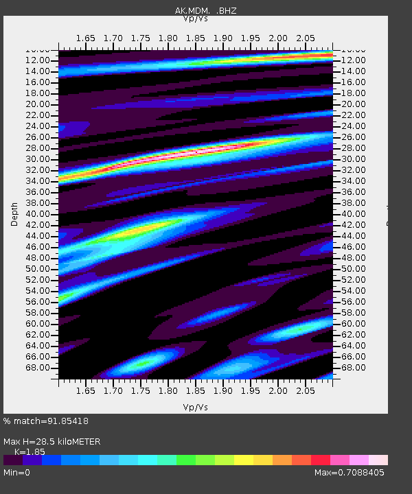
MDM Murphy Dome - Earthquake Result Viewer
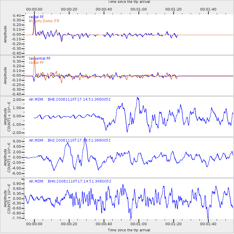
Earthquake location: Minahassa Peninsula, Sulawesi
Earthquake latitude/longitude: 1.3/122.1
Earthquake time(UTC): 2008/11/16 (321) 17:02:32 GMT
Earthquake Depth: 30 km
Earthquake Magnitude: 6.5 MB, 7.0 MS, 7.3 MW, 7.3 MW
Earthquake Catalog/Contributor: WHDF/NEIC
Network: AK Alaska Regional Network
Station: MDM Murphy Dome
Lat/Lon: 64.96 N/148.23 W
Elevation: 634 m
Distance: 88.7 deg
Az: 25.195 deg
Baz: 270.248 deg
Ray Param: 0.04233879
Estimated Moho Depth: 28.5 km
Estimated Crust Vp/Vs: 1.85
Assumed Crust Vp: 6.566 km/s
Estimated Crust Vs: 3.549 km/s
Estimated Crust Poisson's Ratio: 0.29
Radial Match: 91.85418 %
Radial Bump: 372
Transverse Match: 74.42031 %
Transverse Bump: 400
SOD ConfigId: 2658
Insert Time: 2010-03-09 13:29:42.548 +0000
GWidth: 2.5
Max Bumps: 400
Tol: 0.001

Signal To Noise

ChannelStoNSTALTA
AK:MDM: :BHZ:20081116T17:14:51.968005Z3.33046255.2751693E-71.583915E-7
AK:MDM: :BHN:20081116T17:14:51.968005Z0.52333887.764105E-81.4835715E-7
AK:MDM: :BHE:20081116T17:14:51.968005Z1.83185352.0506587E-71.1194447E-7
Arrivals
Ps3.8 SECOND
PpPs12 SECOND
PsPs/PpSs16 SECOND