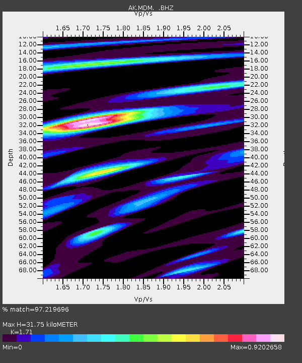
MDM Murphy Dome - Earthquake Result Viewer

Earthquake location: Andaman Islands, India Region
Earthquake latitude/longitude: 14.1/92.9
Earthquake time(UTC): 2009/08/10 (222) 19:55:35 GMT
Earthquake Depth: 4.7 km
Earthquake Magnitude: 6.9 MB, 7.6 MS, 7.5 MW, 7.5 MW
Earthquake Catalog/Contributor: WHDF/NEIC
Network: AK Alaska Regional Network
Station: MDM Murphy Dome
Lat/Lon: 64.96 N/148.23 W
Elevation: 634 m
Distance: 88.9 deg
Az: 21.885 deg
Baz: 301.818 deg
Ray Param: 0.042267215
Estimated Moho Depth: 31.75 km
Estimated Crust Vp/Vs: 1.71
Assumed Crust Vp: 6.566 km/s
Estimated Crust Vs: 3.84 km/s
Estimated Crust Poisson's Ratio: 0.24
Radial Match: 97.219696 %
Radial Bump: 400
Transverse Match: 92.632095 %
Transverse Bump: 400
SOD ConfigId: 2622
Insert Time: 2010-03-09 13:29:49.019 +0000
GWidth: 2.5
Max Bumps: 400
Tol: 0.001

Signal To Noise

ChannelStoNSTALTA
AK:MDM: :BHZ:20090810T20:07:59.287002Z37.0380672.0676673E-65.5825467E-8
AK:MDM: :BHN:20090810T20:07:59.287002Z2.6139493.231466E-71.236239E-7
AK:MDM: :BHE:20090810T20:07:59.287002Z11.2230674.3235542E-73.852382E-8
Arrivals
Ps3.5 SECOND
PpPs13 SECOND
PsPs/PpSs16 SECOND