You are here: Home > Network List > TA - USArray Transportable Network (new EarthScope stations) Stations List
> Station TOLK Toolik Lake Research Station, AK, USA > Earthquake Result Viewer
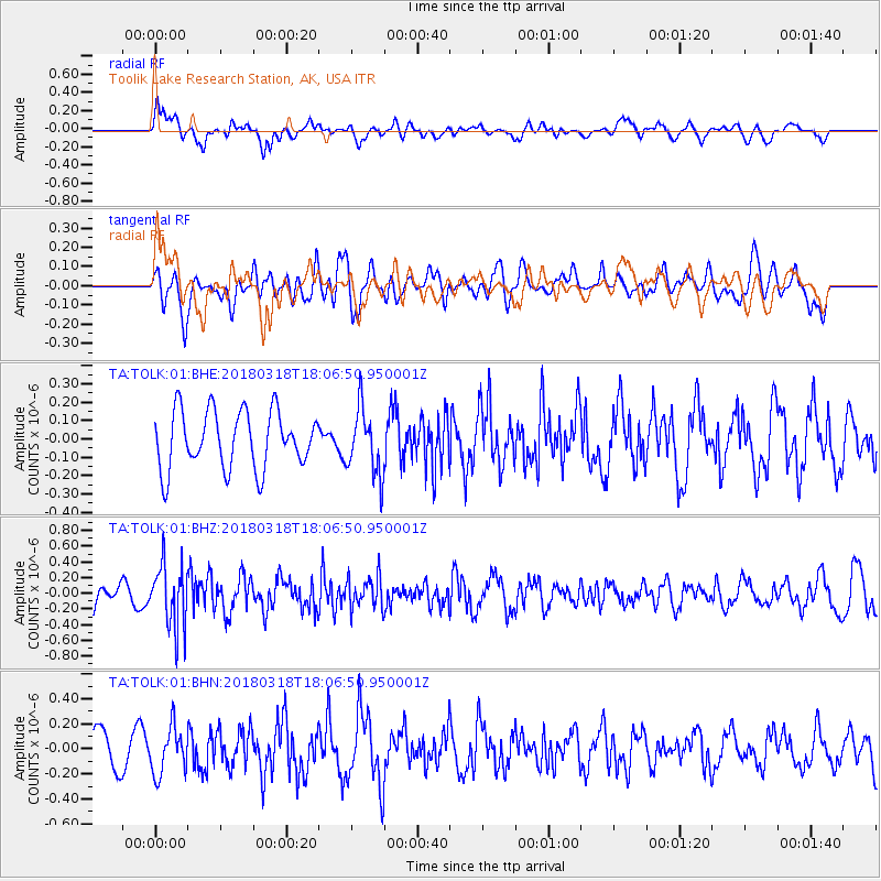
TOLK Toolik Lake Research Station, AK, USA - Earthquake Result Viewer
*The percent match for this event was below the threshold and hence no stack was calculated.
| Earthquake location: |
Kuril Islands |
| Earthquake latitude/longitude: |
45.3/150.3 |
| Earthquake time(UTC): |
2018/03/18 (077) 18:00:10 GMT |
| Earthquake Depth: |
72 km |
| Earthquake Magnitude: |
5.1 Mww |
| Earthquake Catalog/Contributor: |
NEIC PDE/us |
|
| Network: |
TA USArray Transportable Network (new EarthScope stations) |
| Station: |
TOLK Toolik Lake Research Station, AK, USA |
| Lat/Lon: |
68.64 N/149.57 W |
| Elevation: |
760 m |
|
| Distance: |
38.0 deg |
| Az: |
31.081 deg |
| Baz: |
263.733 deg |
| Ray Param: |
$rayparam |
*The percent match for this event was below the threshold and hence was not used in the summary stack. |
|
| Radial Match: |
61.054462 % |
| Radial Bump: |
400 |
| Transverse Match: |
57.57772 % |
| Transverse Bump: |
400 |
| SOD ConfigId: |
2643891 |
| Insert Time: |
2018-04-16 16:17:27.059 +0000 |
| GWidth: |
2.5 |
| Max Bumps: |
400 |
| Tol: |
0.001 |
|
Signal To Noise
| Channel | StoN | STA | LTA |
| TA:TOLK:01:BHZ:20180318T18:06:50.950001Z | 3.323864 | 3.9925033E-7 | 1.2011633E-7 |
| TA:TOLK:01:BHN:20180318T18:06:50.950001Z | 1.41131 | 1.8328396E-7 | 1.2986797E-7 |
| TA:TOLK:01:BHE:20180318T18:06:50.950001Z | 1.1584672 | 1.8060986E-7 | 1.5590416E-7 |
| Arrivals |
| Ps | |
| PpPs | |
| PsPs/PpSs | |


