You are here: Home > Network List > US - United States National Seismic Network Stations List
> Station DGMT Dagmar, Montana, USA > Earthquake Result Viewer
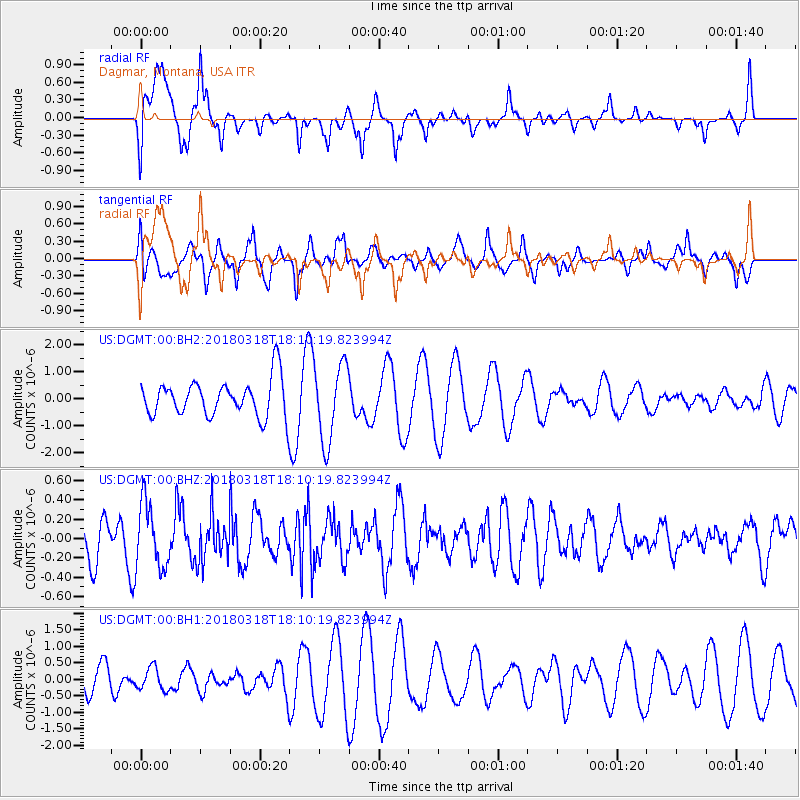
DGMT Dagmar, Montana, USA - Earthquake Result Viewer
*The percent match for this event was below the threshold and hence no stack was calculated.
| Earthquake location: |
Kuril Islands |
| Earthquake latitude/longitude: |
45.3/150.3 |
| Earthquake time(UTC): |
2018/03/18 (077) 18:00:10 GMT |
| Earthquake Depth: |
72 km |
| Earthquake Magnitude: |
5.1 Mww |
| Earthquake Catalog/Contributor: |
NEIC PDE/us |
|
| Network: |
US United States National Seismic Network |
| Station: |
DGMT Dagmar, Montana, USA |
| Lat/Lon: |
48.47 N/104.20 W |
| Elevation: |
0.0 m |
|
| Distance: |
66.2 deg |
| Az: |
44.496 deg |
| Baz: |
312.024 deg |
| Ray Param: |
$rayparam |
*The percent match for this event was below the threshold and hence was not used in the summary stack. |
|
| Radial Match: |
62.174004 % |
| Radial Bump: |
356 |
| Transverse Match: |
43.910824 % |
| Transverse Bump: |
354 |
| SOD ConfigId: |
2643891 |
| Insert Time: |
2018-04-16 16:18:24.327 +0000 |
| GWidth: |
2.5 |
| Max Bumps: |
400 |
| Tol: |
0.001 |
|
Signal To Noise
| Channel | StoN | STA | LTA |
| US:DGMT:00:BHZ:20180318T18:10:19.823994Z | 1.0758564 | 3.311621E-7 | 3.078125E-7 |
| US:DGMT:00:BH1:20180318T18:10:19.823994Z | 0.5066485 | 3.400439E-7 | 6.711634E-7 |
| US:DGMT:00:BH2:20180318T18:10:19.823994Z | 2.108312 | 1.4323849E-6 | 6.7939897E-7 |
| Arrivals |
| Ps | |
| PpPs | |
| PsPs/PpSs | |


