You are here: Home > Network List > AU - Australian Seismological Centre Stations List
> Station MAW Mawson, Antarctica > Earthquake Result Viewer
MAW Mawson, Antarctica - Earthquake Result Viewer
| Earthquake location: |
Macquarie Island Region |
| Earthquake latitude/longitude: |
-58.8/158.6 |
| Earthquake time(UTC): |
2021/10/07 (280) 20:13:01 GMT |
| Earthquake Depth: |
10 km |
| Earthquake Magnitude: |
5.9 mwb |
| Earthquake Catalog/Contributor: |
NEIC PDE/us |
|
| Network: |
AU Australian Seismological Centre |
| Station: |
MAW Mawson, Antarctica |
| Lat/Lon: |
67.60 S/62.87 E |
| Elevation: |
12 m |
|
| Distance: |
39.8 deg |
| Az: |
216.564 deg |
| Baz: |
125.884 deg |
| Ray Param: |
0.07477728 |
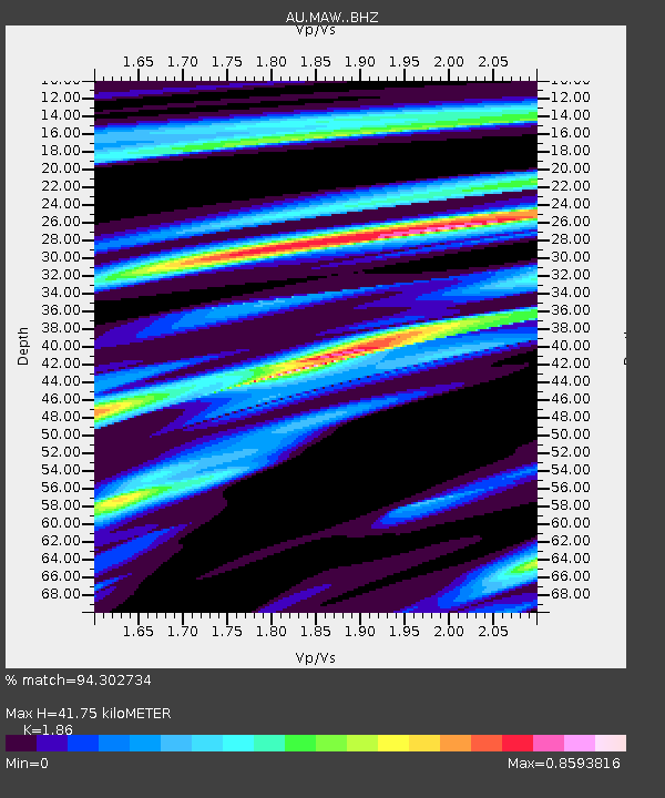
| Estimated Moho Depth: |
41.75 km |
| Estimated Crust Vp/Vs: |
1.86 |
| Assumed Crust Vp: |
6.508 km/s |
| Estimated Crust Vs: |
3.499 km/s |
| Estimated Crust Poisson's Ratio: |
0.30 |
|
| Radial Match: |
94.302734 % |
| Radial Bump: |
390 |
| Transverse Match: |
49.751534 % |
| Transverse Bump: |
400 |
| SOD ConfigId: |
26497111 |
| Insert Time: |
2021-10-21 20:14:09.332 +0000 |
| GWidth: |
2.5 |
| Max Bumps: |
400 |
| Tol: |
0.001 |
|

Signal To Noise
| Channel | StoN | STA | LTA |
| AU:MAW: :BHZ:20211007T20:20:03.450005Z | 7.235673 | 1.7798065E-7 | 2.4597664E-8 |
| AU:MAW: :BHN:20211007T20:20:03.450005Z | 4.0423503 | 6.538793E-8 | 1.617572E-8 |
| AU:MAW: :BHE:20211007T20:20:03.450005Z | 5.2741675 | 8.909755E-8 | 1.6893196E-8 |
| Arrivals |
| Ps | 5.9 SECOND |
| PpPs | 17 SECOND |
| PsPs/PpSs | 23 SECOND |


