You are here: Home > Network List > G - GEOSCOPE Stations List
> Station INU Inuyama, Japan > Earthquake Result Viewer
INU Inuyama, Japan - Earthquake Result Viewer
*The percent match for this event was below the threshold and hence no stack was calculated.
| Earthquake location: |
Macquarie Island Region |
| Earthquake latitude/longitude: |
-58.8/158.6 |
| Earthquake time(UTC): |
2021/10/07 (280) 20:13:01 GMT |
| Earthquake Depth: |
10 km |
| Earthquake Magnitude: |
5.9 mwb |
| Earthquake Catalog/Contributor: |
NEIC PDE/us |
|
| Network: |
G GEOSCOPE |
| Station: |
INU Inuyama, Japan |
| Lat/Lon: |
35.35 N/137.03 E |
| Elevation: |
132 m |
|
| Distance: |
95.5 deg |
| Az: |
342.422 deg |
| Baz: |
168.899 deg |
| Ray Param: |
$rayparam |
*The percent match for this event was below the threshold and hence was not used in the summary stack. |
|
| Radial Match: |
52.211758 % |
| Radial Bump: |
400 |
| Transverse Match: |
50.49977 % |
| Transverse Bump: |
400 |
| SOD ConfigId: |
26497111 |
| Insert Time: |
2021-10-21 20:15:55.243 +0000 |
| GWidth: |
2.5 |
| Max Bumps: |
400 |
| Tol: |
0.001 |
|
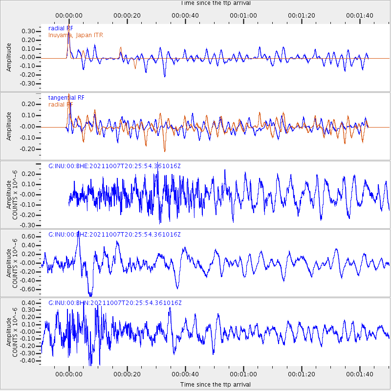
Signal To Noise
| Channel | StoN | STA | LTA |
| G:INU:00:BHZ:20211007T20:25:54.361016Z | 3.0018165 | 2.8695905E-7 | 9.5595134E-8 |
| G:INU:00:BHN:20211007T20:25:54.361016Z | 1.4569753 | 1.556029E-7 | 1.0679858E-7 |
| G:INU:00:BHE:20211007T20:25:54.361016Z | 2.0107398 | 1.3585026E-7 | 6.7562326E-8 |
| Arrivals |
| Ps | |
| PpPs | |
| PsPs/PpSs | |


