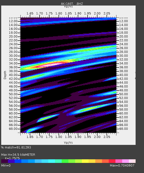
CAST Castle Rocks - Earthquake Result Viewer

Earthquake location: Santa Cruz Islands Region
Earthquake latitude/longitude: -11.0/164.5
Earthquake time(UTC): 2008/07/19 (201) 09:27:01 GMT
Earthquake Depth: 11 km
Earthquake Magnitude: 6.1 MB, 6.4 MS, 6.6 MW, 6.6 MW
Earthquake Catalog/Contributor: WHDF/NEIC
Network: AK Alaska Regional Network
Station: CAST Castle Rocks
Lat/Lon: 63.42 N/152.08 W
Elevation: 611 m
Distance: 81.3 deg
Az: 18.229 deg
Baz: 223.051 deg
Ray Param: 0.047663894
Estimated Moho Depth: 34.5 km
Estimated Crust Vp/Vs: 1.76
Assumed Crust Vp: 6.566 km/s
Estimated Crust Vs: 3.736 km/s
Estimated Crust Poisson's Ratio: 0.26
Radial Match: 91.81293 %
Radial Bump: 389
Transverse Match: 73.5937 %
Transverse Bump: 400
SOD ConfigId: 2658
Insert Time: 2010-03-09 13:30:25.656 +0000
GWidth: 2.5
Max Bumps: 400
Tol: 0.001

Signal To Noise

ChannelStoNSTALTA
AK:CAST: :BHZ:20080719T09:38:46.387002Z47.7960243.197416E-66.689711E-8
AK:CAST: :BHN:20080719T09:38:46.387002Z7.1834871.2171688E-61.6943983E-7
AK:CAST: :BHE:20080719T09:38:46.387002Z3.22199823.55221E-71.1024867E-7
Arrivals
Ps4.1 SECOND
PpPs14 SECOND
PsPs/PpSs18 SECOND