You are here: Home > Network List > CI - Caltech Regional Seismic Network Stations List
> Station LRL Laurel Mtn Radio Fac, Ridgecrest, CA, USA > Earthquake Result Viewer
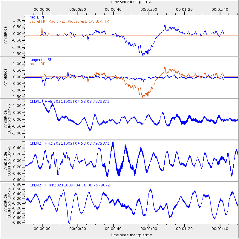
LRL Laurel Mtn Radio Fac, Ridgecrest, CA, USA - Earthquake Result Viewer
*The percent match for this event was below the threshold and hence no stack was calculated.
| Earthquake location: |
Southern Peru |
| Earthquake latitude/longitude: |
-15.6/-71.9 |
| Earthquake time(UTC): |
2021/10/09 (282) 04:47:50 GMT |
| Earthquake Depth: |
24 km |
| Earthquake Magnitude: |
5.6 mww |
| Earthquake Catalog/Contributor: |
NEIC PDE/us |
|
| Network: |
CI Caltech Regional Seismic Network |
| Station: |
LRL Laurel Mtn Radio Fac, Ridgecrest, CA, USA |
| Lat/Lon: |
35.48 N/117.68 W |
| Elevation: |
1340 m |
|
| Distance: |
66.8 deg |
| Az: |
320.447 deg |
| Baz: |
131.245 deg |
| Ray Param: |
$rayparam |
*The percent match for this event was below the threshold and hence was not used in the summary stack. |
|
| Radial Match: |
48.327885 % |
| Radial Bump: |
400 |
| Transverse Match: |
59.1232 % |
| Transverse Bump: |
400 |
| SOD ConfigId: |
26497111 |
| Insert Time: |
2021-10-23 04:52:17.078 +0000 |
| GWidth: |
2.5 |
| Max Bumps: |
400 |
| Tol: |
0.001 |
|
Signal To Noise
| Channel | StoN | STA | LTA |
| CI:LRL: :HHZ:20211009T04:58:08.797987Z | 2.17973 | 1.8673562E-7 | 8.566916E-8 |
| CI:LRL: :HHN:20211009T04:58:08.797987Z | 0.9177338 | 4.4423405E-7 | 4.840555E-7 |
| CI:LRL: :HHE:20211009T04:58:08.797987Z | 0.93681973 | 4.3017928E-7 | 4.591911E-7 |
| Arrivals |
| Ps | |
| PpPs | |
| PsPs/PpSs | |


