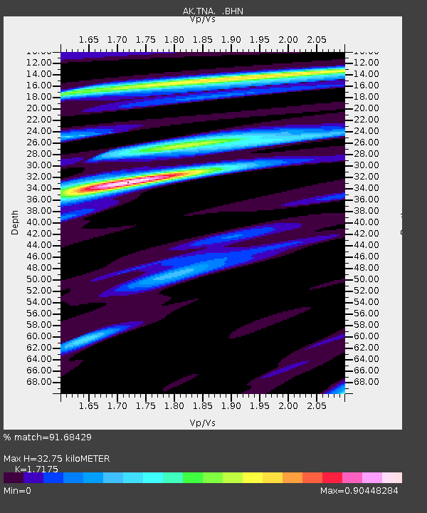
TNA Tin City Broadband - Earthquake Result Viewer

Earthquake location: Near East Coast Of Honshu, Japan
Earthquake latitude/longitude: 38.1/142.1
Earthquake time(UTC): 2005/12/02 (336) 13:13:09 GMT
Earthquake Depth: 29 km
Earthquake Magnitude: 6.1 MB, 6.3 MS, 6.5 MW, 6.4 MW
Earthquake Catalog/Contributor: WHDF/NEIC
Network: AK Alaska Regional Network
Station: TNA Tin City Broadband
Lat/Lon: 65.56 N/167.92 W
Elevation: 74 m
Distance: 39.7 deg
Az: 29.935 deg
Baz: 251.162 deg
Ray Param: 0.074804135
Estimated Moho Depth: 32.75 km
Estimated Crust Vp/Vs: 1.72
Assumed Crust Vp: 6.307 km/s
Estimated Crust Vs: 3.672 km/s
Estimated Crust Poisson's Ratio: 0.24
Radial Match: 91.68429 %
Radial Bump: 292
Transverse Match: 68.24857 %
Transverse Bump: 378
SOD ConfigId: 2422
Insert Time: 2010-03-09 13:32:32.163 +0000
GWidth: 2.5
Max Bumps: 400
Tol: 0.001

Signal To Noise

ChannelStoNSTALTA
AK:TNA: :BHN:20051202T13:20:08.240001Z3.41739545.985009E-71.7513365E-7
AK:TNA: :BHE:20051202T13:20:08.240001Z4.81802037.3697623E-71.5296246E-7
AK:TNA: :BHZ:20051202T13:20:08.240001Z6.2648892.6013429E-64.152257E-7
Arrivals
Ps4.0 SECOND
PpPs13 SECOND
PsPs/PpSs17 SECOND