You are here: Home > Network List > AK - Alaska Regional Network Stations List
> Station TNA Tin City Broadband > Earthquake Result Viewer
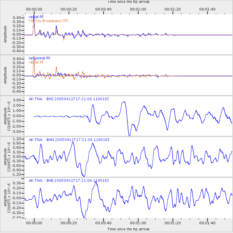
TNA Tin City Broadband - Earthquake Result Viewer

| Earthquake location: |
Southeast Of Loyalty Islands |
| Earthquake latitude/longitude: |
-22.0/170.6 |
| Earthquake time(UTC): |
2005/04/11 (101) 17:08:53 GMT |
| Earthquake Depth: |
68 km |
| Earthquake Magnitude: |
6.0 MB, 6.8 MW, 6.8 MW |
| Earthquake Catalog/Contributor: |
WHDF/NEIC |
|
| Network: |
AK Alaska Regional Network |
| Station: |
TNA Tin City Broadband |
| Lat/Lon: |
65.56 N/167.92 W |
| Elevation: |
74 m |
|
| Distance: |
88.8 deg |
| Az: |
8.758 deg |
| Baz: |
199.86 deg |
| Ray Param: |
0.042196296 |
| Estimated Moho Depth: |
27.0 km |
| Estimated Crust Vp/Vs: |
2.08 |
| Assumed Crust Vp: |
6.307 km/s |
| Estimated Crust Vs: |
3.028 km/s |
| Estimated Crust Poisson's Ratio: |
0.35 |
|
| Radial Match: |
95.62513 % |
| Radial Bump: |
295 |
| Transverse Match: |
83.87984 % |
| Transverse Bump: |
400 |
| SOD ConfigId: |
2459 |
| Insert Time: |
2010-03-09 13:32:40.918 +0000 |
| GWidth: |
2.5 |
| Max Bumps: |
400 |
| Tol: |
0.001 |
|
Signal To Noise
| Channel | StoN | STA | LTA |
| AK:TNA: :BHN:20050411T17:21:09.119016Z | 4.7583632 | 4.0462632E-7 | 8.503477E-8 |
| AK:TNA: :BHE:20050411T17:21:09.119016Z | 1.7046078 | 1.1079147E-7 | 6.4995284E-8 |
| AK:TNA: :BHZ:20050411T17:21:09.119016Z | 15.199886 | 1.0558613E-6 | 6.946508E-8 |
| Arrivals |
| Ps | 4.7 SECOND |
| PpPs | 13 SECOND |
| PsPs/PpSs | 18 SECOND |


