You are here: Home > Network List > US - United States National Seismic Network Stations List
> Station DGMT Dagmar, Montana, USA > Earthquake Result Viewer
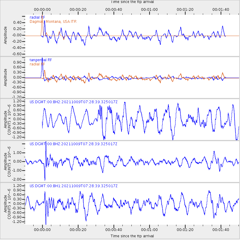
DGMT Dagmar, Montana, USA - Earthquake Result Viewer
*The percent match for this event was below the threshold and hence no stack was calculated.
| Earthquake location: |
Sea Of Okhotsk |
| Earthquake latitude/longitude: |
50.0/149.8 |
| Earthquake time(UTC): |
2021/10/09 (282) 07:19:27 GMT |
| Earthquake Depth: |
448 km |
| Earthquake Magnitude: |
5.6 Mww |
| Earthquake Catalog/Contributor: |
NEIC PDE/us |
|
| Network: |
US United States National Seismic Network |
| Station: |
DGMT Dagmar, Montana, USA |
| Lat/Lon: |
48.47 N/104.20 W |
| Elevation: |
0.0 m |
|
| Distance: |
63.1 deg |
| Az: |
45.839 deg |
| Baz: |
315.965 deg |
| Ray Param: |
$rayparam |
*The percent match for this event was below the threshold and hence was not used in the summary stack. |
|
| Radial Match: |
46.79941 % |
| Radial Bump: |
400 |
| Transverse Match: |
85.20226 % |
| Transverse Bump: |
318 |
| SOD ConfigId: |
26497111 |
| Insert Time: |
2021-10-23 07:44:31.262 +0000 |
| GWidth: |
2.5 |
| Max Bumps: |
400 |
| Tol: |
0.001 |
|
Signal To Noise
| Channel | StoN | STA | LTA |
| US:DGMT:00:BHZ:20211009T07:28:39.325017Z | 2.7073045 | 7.339431E-7 | 2.7109738E-7 |
| US:DGMT:00:BH1:20211009T07:28:39.325017Z | 1.1974112 | 4.1996867E-7 | 3.5073055E-7 |
| US:DGMT:00:BH2:20211009T07:28:39.325017Z | 1.5332698 | 6.3259296E-7 | 4.1257772E-7 |
| Arrivals |
| Ps | |
| PpPs | |
| PsPs/PpSs | |


