You are here: Home > Network List > US - United States National Seismic Network Stations List
> Station EGMT Eagleton, Montana, USA > Earthquake Result Viewer
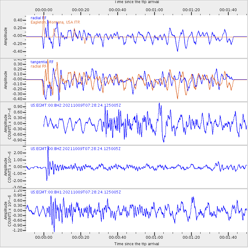
EGMT Eagleton, Montana, USA - Earthquake Result Viewer
*The percent match for this event was below the threshold and hence no stack was calculated.
| Earthquake location: |
Sea Of Okhotsk |
| Earthquake latitude/longitude: |
50.0/149.8 |
| Earthquake time(UTC): |
2021/10/09 (282) 07:19:27 GMT |
| Earthquake Depth: |
448 km |
| Earthquake Magnitude: |
5.6 Mww |
| Earthquake Catalog/Contributor: |
NEIC PDE/us |
|
| Network: |
US United States National Seismic Network |
| Station: |
EGMT Eagleton, Montana, USA |
| Lat/Lon: |
48.02 N/109.75 W |
| Elevation: |
1055 m |
|
| Distance: |
60.8 deg |
| Az: |
49.158 deg |
| Baz: |
313.39 deg |
| Ray Param: |
$rayparam |
*The percent match for this event was below the threshold and hence was not used in the summary stack. |
|
| Radial Match: |
54.174 % |
| Radial Bump: |
400 |
| Transverse Match: |
48.687492 % |
| Transverse Bump: |
400 |
| SOD ConfigId: |
26497111 |
| Insert Time: |
2021-10-23 07:44:36.474 +0000 |
| GWidth: |
2.5 |
| Max Bumps: |
400 |
| Tol: |
0.001 |
|
Signal To Noise
| Channel | StoN | STA | LTA |
| US:EGMT:00:BHZ:20211009T07:28:24.125005Z | 8.160359 | 9.1929513E-7 | 1.1265375E-7 |
| US:EGMT:00:BH1:20211009T07:28:24.125005Z | 1.5337172 | 3.5729875E-7 | 2.329626E-7 |
| US:EGMT:00:BH2:20211009T07:28:24.125005Z | 1.5502491 | 3.563653E-7 | 2.2987614E-7 |
| Arrivals |
| Ps | |
| PpPs | |
| PsPs/PpSs | |


