You are here: Home > Network List > AU - Australian Seismological Centre Stations List
> Station KLBR Kellerberrin, Western Australia > Earthquake Result Viewer
KLBR Kellerberrin, Western Australia - Earthquake Result Viewer
| Earthquake location: |
Vanuatu Islands Region |
| Earthquake latitude/longitude: |
-21.2/174.5 |
| Earthquake time(UTC): |
2021/10/09 (282) 10:58:30 GMT |
| Earthquake Depth: |
520 km |
| Earthquake Magnitude: |
6.9 mww |
| Earthquake Catalog/Contributor: |
NEIC PDE/us |
|
| Network: |
AU Australian Seismological Centre |
| Station: |
KLBR Kellerberrin, Western Australia |
| Lat/Lon: |
31.59 S/117.75 E |
| Elevation: |
320 m |
|
| Distance: |
51.4 deg |
| Az: |
245.945 deg |
| Baz: |
92.919 deg |
| Ray Param: |
0.06514544 |
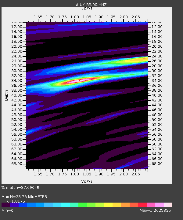
| Estimated Moho Depth: |
33.75 km |
| Estimated Crust Vp/Vs: |
1.82 |
| Assumed Crust Vp: |
6.419 km/s |
| Estimated Crust Vs: |
3.532 km/s |
| Estimated Crust Poisson's Ratio: |
0.28 |
|
| Radial Match: |
87.69049 % |
| Radial Bump: |
170 |
| Transverse Match: |
69.92318 % |
| Transverse Bump: |
400 |
| SOD ConfigId: |
26497111 |
| Insert Time: |
2021-10-23 11:04:08.309 +0000 |
| GWidth: |
2.5 |
| Max Bumps: |
400 |
| Tol: |
0.001 |
|

Signal To Noise
| Channel | StoN | STA | LTA |
| AU:KLBR:00:HHZ:20211009T11:06:16.660014Z | 30.78721 | 1.4899609E-5 | 4.8395447E-7 |
| AU:KLBR:00:HHN:20211009T11:06:16.660014Z | 3.4154205 | 1.4708856E-6 | 4.3066018E-7 |
| AU:KLBR:00:HHE:20211009T11:06:16.660014Z | 16.535603 | 7.832357E-6 | 4.7366626E-7 |
| Arrivals |
| Ps | 4.5 SECOND |
| PpPs | 14 SECOND |
| PsPs/PpSs | 19 SECOND |


