You are here: Home > Network List > AV - Alaska Volcano Observatory Stations List
> Station KOFP Flat Point, Korovin Volcano, Alaska > Earthquake Result Viewer
KOFP Flat Point, Korovin Volcano, Alaska - Earthquake Result Viewer
| Earthquake location: |
Vanuatu Islands Region |
| Earthquake latitude/longitude: |
-21.2/174.5 |
| Earthquake time(UTC): |
2021/10/09 (282) 10:58:30 GMT |
| Earthquake Depth: |
520 km |
| Earthquake Magnitude: |
6.9 mww |
| Earthquake Catalog/Contributor: |
NEIC PDE/us |
|
| Network: |
AV Alaska Volcano Observatory |
| Station: |
KOFP Flat Point, Korovin Volcano, Alaska |
| Lat/Lon: |
52.27 N/174.10 W |
| Elevation: |
662 m |
|
| Distance: |
73.8 deg |
| Az: |
7.248 deg |
| Baz: |
191.048 deg |
| Ray Param: |
0.05110276 |
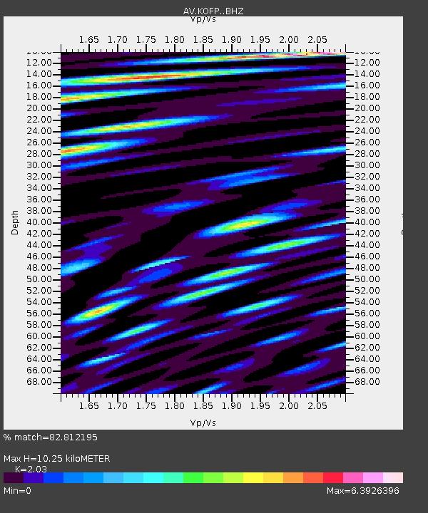
| Estimated Moho Depth: |
10.25 km |
| Estimated Crust Vp/Vs: |
2.03 |
| Assumed Crust Vp: |
5.88 km/s |
| Estimated Crust Vs: |
2.897 km/s |
| Estimated Crust Poisson's Ratio: |
0.34 |
|
| Radial Match: |
82.812195 % |
| Radial Bump: |
400 |
| Transverse Match: |
81.75685 % |
| Transverse Bump: |
400 |
| SOD ConfigId: |
26497111 |
| Insert Time: |
2021-10-23 11:06:15.966 +0000 |
| GWidth: |
2.5 |
| Max Bumps: |
400 |
| Tol: |
0.001 |
|
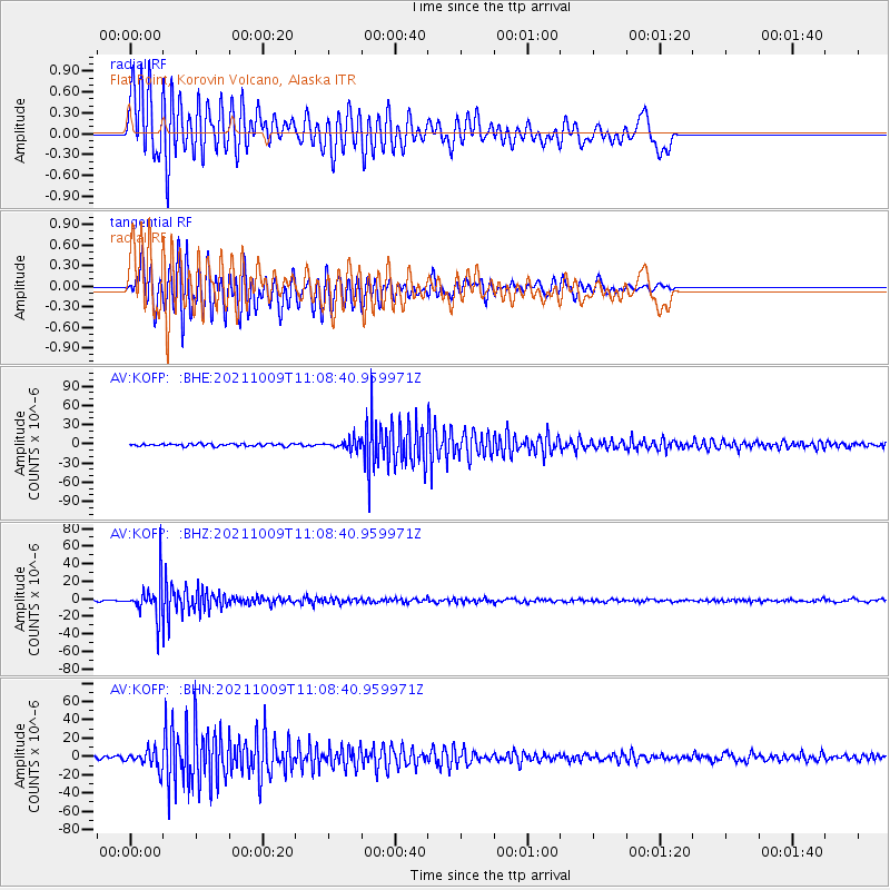
Signal To Noise
| Channel | StoN | STA | LTA |
| AV:KOFP: :BHZ:20211009T11:08:40.959971Z | 16.463503 | 2.0370171E-5 | 1.2372926E-6 |
| AV:KOFP: :BHN:20211009T11:08:40.959971Z | 5.078114 | 9.97207E-6 | 1.963735E-6 |
| AV:KOFP: :BHE:20211009T11:08:40.959971Z | 3.9895842 | 7.610061E-6 | 1.907482E-6 |
| Arrivals |
| Ps | 1.8 SECOND |
| PpPs | 5.2 SECOND |
| PsPs/PpSs | 7.0 SECOND |


