You are here: Home > Network List > CC - Cascade Chain Volcano Monitoring Stations List
> Station REM Rembrant, Mount St. Helens > Earthquake Result Viewer
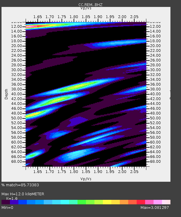
REM Rembrant, Mount St. Helens - Earthquake Result Viewer
| Earthquake location: |
Vanuatu Islands Region |
| Earthquake latitude/longitude: |
-21.2/174.5 |
| Earthquake time(UTC): |
2021/10/09 (282) 10:58:30 GMT |
| Earthquake Depth: |
520 km |
| Earthquake Magnitude: |
6.9 mww |
| Earthquake Catalog/Contributor: |
NEIC PDE/us |
|
| Network: |
CC Cascade Chain Volcano Monitoring |
| Station: |
REM Rembrant, Mount St. Helens |
| Lat/Lon: |
46.20 N/122.19 W |
| Elevation: |
1905 m |
|
| Distance: |
88.1 deg |
| Az: |
38.372 deg |
| Baz: |
236.527 deg |
| Ray Param: |
0.04172453 |
| Estimated Moho Depth: |
12.0 km |
| Estimated Crust Vp/Vs: |
1.60 |
| Assumed Crust Vp: |
6.566 km/s |
| Estimated Crust Vs: |
4.104 km/s |
| Estimated Crust Poisson's Ratio: |
0.18 |
|
| Radial Match: |
85.73383 % |
| Radial Bump: |
400 |
| Transverse Match: |
93.38119 % |
| Transverse Bump: |
400 |
| SOD ConfigId: |
26497111 |
| Insert Time: |
2021-10-23 11:09:55.256 +0000 |
| GWidth: |
2.5 |
| Max Bumps: |
400 |
| Tol: |
0.001 |
|

Signal To Noise
| Channel | StoN | STA | LTA |
| CC:REM: :BHZ:20211009T11:09:54.50001Z | 9.291402 | 1.547021E-6 | 1.6650029E-7 |
| CC:REM: :BHN:20211009T11:09:54.50001Z | 1.1879096 | 5.020015E-7 | 4.2259234E-7 |
| CC:REM: :BHE:20211009T11:09:54.50001Z | 1.1111134 | 5.1045464E-7 | 4.5940823E-7 |
| Arrivals |
| Ps | 1.1 SECOND |
| PpPs | 4.6 SECOND |
| PsPs/PpSs | 5.8 SECOND |


