You are here: Home > Network List > CI - Caltech Regional Seismic Network Stations List
> Station MPM Manuel Prospect Mine, California, USA > Earthquake Result Viewer
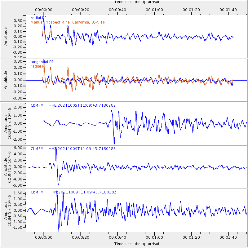
MPM Manuel Prospect Mine, California, USA - Earthquake Result Viewer
*The percent match for this event was below the threshold and hence no stack was calculated.
| Earthquake location: |
Vanuatu Islands Region |
| Earthquake latitude/longitude: |
-21.2/174.5 |
| Earthquake time(UTC): |
2021/10/09 (282) 10:58:30 GMT |
| Earthquake Depth: |
520 km |
| Earthquake Magnitude: |
6.9 mww |
| Earthquake Catalog/Contributor: |
NEIC PDE/us |
|
| Network: |
CI Caltech Regional Seismic Network |
| Station: |
MPM Manuel Prospect Mine, California, USA |
| Lat/Lon: |
36.06 N/117.49 W |
| Elevation: |
185 m |
|
| Distance: |
85.8 deg |
| Az: |
48.87 deg |
| Baz: |
240.177 deg |
| Ray Param: |
$rayparam |
*The percent match for this event was below the threshold and hence was not used in the summary stack. |
|
| Radial Match: |
75.44731 % |
| Radial Bump: |
400 |
| Transverse Match: |
68.8557 % |
| Transverse Bump: |
400 |
| SOD ConfigId: |
26497111 |
| Insert Time: |
2021-10-23 11:11:13.821 +0000 |
| GWidth: |
2.5 |
| Max Bumps: |
400 |
| Tol: |
0.001 |
|
Signal To Noise
| Channel | StoN | STA | LTA |
| CI:MPM: :HHZ:20211009T11:09:43.718028Z | 2.0696862 | 5.2916226E-7 | 2.556727E-7 |
| CI:MPM: :HHN:20211009T11:09:43.718028Z | 0.8672588 | 1.2603238E-7 | 1.4532267E-7 |
| CI:MPM: :HHE:20211009T11:09:43.718028Z | 0.8400678 | 1.4441204E-7 | 1.7190521E-7 |
| Arrivals |
| Ps | |
| PpPs | |
| PsPs/PpSs | |


