You are here: Home > Network List > AK - Alaska Regional Network Stations List
> Station BPAW Bear Paw Mountain Broadband > Earthquake Result Viewer
BPAW Bear Paw Mountain Broadband - Earthquake Result Viewer
| Earthquake location: |
Philippine Islands Region |
| Earthquake latitude/longitude: |
13.4/125.6 |
| Earthquake time(UTC): |
2008/03/03 (063) 14:11:14 GMT |
| Earthquake Depth: |
24 km |
| Earthquake Magnitude: |
6.4 MB, 6.9 MW, 6.8 MW |
| Earthquake Catalog/Contributor: |
WHDF/NEIC |
|
| Network: |
AK Alaska Regional Network |
| Station: |
BPAW Bear Paw Mountain Broadband |
| Lat/Lon: |
64.10 N/150.98 W |
| Elevation: |
619 m |
|
| Distance: |
75.2 deg |
| Az: |
26.822 deg |
| Baz: |
270.002 deg |
| Ray Param: |
0.051798347 |
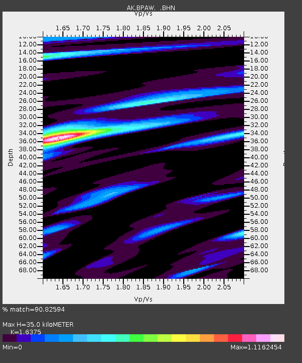
| Estimated Moho Depth: |
35.0 km |
| Estimated Crust Vp/Vs: |
1.64 |
| Assumed Crust Vp: |
6.566 km/s |
| Estimated Crust Vs: |
4.01 km/s |
| Estimated Crust Poisson's Ratio: |
0.20 |
|
| Radial Match: |
90.82594 % |
| Radial Bump: |
327 |
| Transverse Match: |
79.15628 % |
| Transverse Bump: |
387 |
| SOD ConfigId: |
2564 |
| Insert Time: |
2010-03-09 13:34:34.556 +0000 |
| GWidth: |
2.5 |
| Max Bumps: |
400 |
| Tol: |
0.001 |
|

Signal To Noise
| Channel | StoN | STA | LTA |
| AK:BPAW: :BHN:20080303T14:22:23.88001Z | 1.0908077 | 3.2933704E-7 | 3.0192035E-7 |
| AK:BPAW: :BHE:20080303T14:22:23.88001Z | 4.8624797 | 1.1996754E-6 | 2.467209E-7 |
| AK:BPAW: :BHZ:20080303T14:22:23.88001Z | 13.676294 | 4.230053E-6 | 3.0929817E-7 |
| Arrivals |
| Ps | 3.5 SECOND |
| PpPs | 14 SECOND |
| PsPs/PpSs | 17 SECOND |


