You are here: Home > Network List > TM - Thai Seismic Monitoring Network Stations List
> Station CMAI AngKang, ChiangMai > Earthquake Result Viewer
CMAI AngKang, ChiangMai - Earthquake Result Viewer
| Earthquake location: |
Vanuatu Islands Region |
| Earthquake latitude/longitude: |
-21.2/174.5 |
| Earthquake time(UTC): |
2021/10/09 (282) 10:58:30 GMT |
| Earthquake Depth: |
520 km |
| Earthquake Magnitude: |
6.9 mww |
| Earthquake Catalog/Contributor: |
NEIC PDE/us |
|
| Network: |
TM Thai Seismic Monitoring Network |
| Station: |
CMAI AngKang, ChiangMai |
| Lat/Lon: |
19.93 N/99.05 E |
| Elevation: |
1544 m |
|
| Distance: |
84.4 deg |
| Az: |
293.761 deg |
| Baz: |
114.78 deg |
| Ray Param: |
0.044066142 |
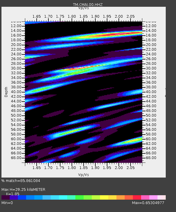
| Estimated Moho Depth: |
29.25 km |
| Estimated Crust Vp/Vs: |
1.85 |
| Assumed Crust Vp: |
6.35 km/s |
| Estimated Crust Vs: |
3.432 km/s |
| Estimated Crust Poisson's Ratio: |
0.29 |
|
| Radial Match: |
85.861084 % |
| Radial Bump: |
298 |
| Transverse Match: |
66.85727 % |
| Transverse Bump: |
400 |
| SOD ConfigId: |
26497111 |
| Insert Time: |
2021-10-23 11:18:29.580 +0000 |
| GWidth: |
2.5 |
| Max Bumps: |
400 |
| Tol: |
0.001 |
|

Signal To Noise
| Channel | StoN | STA | LTA |
| TM:CMAI:00:HHZ:20211009T11:09:36.680003Z | 6.079917 | 1.1782373E-6 | 1.9379168E-7 |
| TM:CMAI:00:HHN:20211009T11:09:36.680003Z | 1.9237783 | 3.1414527E-7 | 1.63296E-7 |
| TM:CMAI:00:HHE:20211009T11:09:36.680003Z | 2.8640542 | 4.6252825E-7 | 1.6149424E-7 |
| Arrivals |
| Ps | 4.0 SECOND |
| PpPs | 13 SECOND |
| PsPs/PpSs | 17 SECOND |


