You are here: Home > Network List > UO - University of Oregon Regional Network Stations List
> Station DFAZ Toketee, OR, USA > Earthquake Result Viewer
DFAZ Toketee, OR, USA - Earthquake Result Viewer
| Earthquake location: |
Vanuatu Islands Region |
| Earthquake latitude/longitude: |
-21.2/174.5 |
| Earthquake time(UTC): |
2021/10/09 (282) 10:58:30 GMT |
| Earthquake Depth: |
520 km |
| Earthquake Magnitude: |
6.9 mww |
| Earthquake Catalog/Contributor: |
NEIC PDE/us |
|
| Network: |
UO University of Oregon Regional Network |
| Station: |
DFAZ Toketee, OR, USA |
| Lat/Lon: |
43.24 N/122.11 W |
| Elevation: |
1948 m |
|
| Distance: |
86.5 deg |
| Az: |
40.875 deg |
| Baz: |
236.698 deg |
| Ray Param: |
0.04253843 |
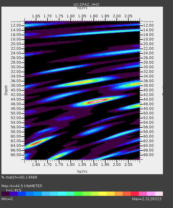
| Estimated Moho Depth: |
44.5 km |
| Estimated Crust Vp/Vs: |
1.91 |
| Assumed Crust Vp: |
6.522 km/s |
| Estimated Crust Vs: |
3.406 km/s |
| Estimated Crust Poisson's Ratio: |
0.31 |
|
| Radial Match: |
80.14969 % |
| Radial Bump: |
400 |
| Transverse Match: |
67.3811 % |
| Transverse Bump: |
400 |
| SOD ConfigId: |
26497111 |
| Insert Time: |
2021-10-23 11:19:12.912 +0000 |
| GWidth: |
2.5 |
| Max Bumps: |
400 |
| Tol: |
0.001 |
|

Signal To Noise
| Channel | StoN | STA | LTA |
| UO:DFAZ: :HHZ:20211009T11:09:47.097972Z | 5.5141296 | 1.0116026E-6 | 1.8345644E-7 |
| UO:DFAZ: :HHN:20211009T11:09:47.097972Z | 1.2074269 | 3.577176E-7 | 2.962644E-7 |
| UO:DFAZ: :HHE:20211009T11:09:47.097972Z | 1.3697337 | 5.9219116E-7 | 4.3234036E-7 |
| Arrivals |
| Ps | 6.4 SECOND |
| PpPs | 19 SECOND |
| PsPs/PpSs | 26 SECOND |


