You are here: Home > Network List > US - United States National Seismic Network Stations List
> Station MNTX Cornudas Mountains, Texas, USA > Earthquake Result Viewer
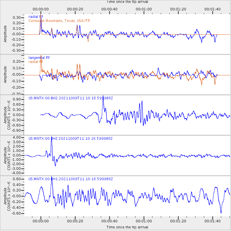
MNTX Cornudas Mountains, Texas, USA - Earthquake Result Viewer
*The percent match for this event was below the threshold and hence no stack was calculated.
| Earthquake location: |
Vanuatu Islands Region |
| Earthquake latitude/longitude: |
-21.2/174.5 |
| Earthquake time(UTC): |
2021/10/09 (282) 10:58:30 GMT |
| Earthquake Depth: |
520 km |
| Earthquake Magnitude: |
6.9 mww |
| Earthquake Catalog/Contributor: |
NEIC PDE/us |
|
| Network: |
US United States National Seismic Network |
| Station: |
MNTX Cornudas Mountains, Texas, USA |
| Lat/Lon: |
31.70 N/105.38 W |
| Elevation: |
405 m |
|
| Distance: |
92.9 deg |
| Az: |
57.221 deg |
| Baz: |
247.011 deg |
| Ray Param: |
$rayparam |
*The percent match for this event was below the threshold and hence was not used in the summary stack. |
|
| Radial Match: |
74.50926 % |
| Radial Bump: |
400 |
| Transverse Match: |
67.02776 % |
| Transverse Bump: |
400 |
| SOD ConfigId: |
26497111 |
| Insert Time: |
2021-10-23 11:20:08.894 +0000 |
| GWidth: |
2.5 |
| Max Bumps: |
400 |
| Tol: |
0.001 |
|
Signal To Noise
| Channel | StoN | STA | LTA |
| US:MNTX:00:BHZ:20211009T11:10:16.599986Z | 2.3246136 | 3.9405467E-7 | 1.6951404E-7 |
| US:MNTX:00:BH1:20211009T11:10:16.599986Z | 2.1027033 | 2.0322271E-7 | 9.66483E-8 |
| US:MNTX:00:BH2:20211009T11:10:16.599986Z | 2.3657963 | 1.916109E-7 | 8.099213E-8 |
| Arrivals |
| Ps | |
| PpPs | |
| PsPs/PpSs | |


