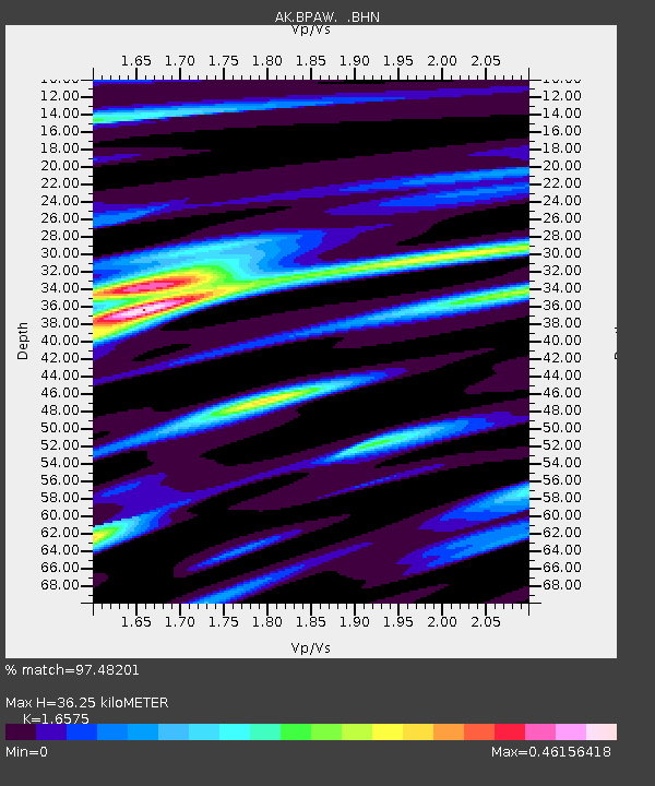
BPAW Bear Paw Mountain Broadband - Earthquake Result Viewer

Earthquake location: Northern Sumatra, Indonesia
Earthquake latitude/longitude: 2.1/97.1
Earthquake time(UTC): 2005/03/28 (087) 16:09:36 GMT
Earthquake Depth: 30 km
Earthquake Magnitude: 7.2 MB, 8.4 MS, 8.7 MW, 8.1 MW
Earthquake Catalog/Contributor: WHDF/NEIC
Network: AK Alaska Regional Network
Station: BPAW Bear Paw Mountain Broadband
Lat/Lon: 64.10 N/150.98 W
Elevation: 619 m
Distance: 97.5 deg
Az: 24.269 deg
Baz: 290.727 deg
Ray Param: 0.0401684
Estimated Moho Depth: 36.25 km
Estimated Crust Vp/Vs: 1.66
Assumed Crust Vp: 6.566 km/s
Estimated Crust Vs: 3.961 km/s
Estimated Crust Poisson's Ratio: 0.21
Radial Match: 97.48201 %
Radial Bump: 400
Transverse Match: 87.25392 %
Transverse Bump: 400
SOD ConfigId: 2459
Insert Time: 2010-03-09 13:35:00.142 +0000
GWidth: 2.5
Max Bumps: 400
Tol: 0.001

Signal To Noise

ChannelStoNSTALTA
AK:BPAW: :BHN:20050328T16:22:36.160005Z2.63301043.2425717E-71.2315074E-7
AK:BPAW: :BHE:20050328T16:22:36.160005Z2.14350723.880778E-71.8104805E-7
AK:BPAW: :BHZ:20050328T16:22:36.160005Z4.07830437.2633844E-71.7809815E-7
Arrivals
Ps3.7 SECOND
PpPs14 SECOND
PsPs/PpSs18 SECOND