You are here: Home > Network List > UW - Pacific Northwest Regional Seismic Network Stations List
> Station IRON Crane, OR, USA > Earthquake Result Viewer
IRON Crane, OR, USA - Earthquake Result Viewer
*The percent match for this event was below the threshold and hence no stack was calculated.
| Earthquake location: |
Vanuatu Islands Region |
| Earthquake latitude/longitude: |
-21.2/174.5 |
| Earthquake time(UTC): |
2021/10/09 (282) 10:58:30 GMT |
| Earthquake Depth: |
520 km |
| Earthquake Magnitude: |
6.9 mww |
| Earthquake Catalog/Contributor: |
NEIC PDE/us |
|
| Network: |
UW Pacific Northwest Regional Seismic Network |
| Station: |
IRON Crane, OR, USA |
| Lat/Lon: |
43.36 N/118.47 W |
| Elevation: |
1226 m |
|
| Distance: |
88.8 deg |
| Az: |
42.184 deg |
| Baz: |
239.236 deg |
| Ray Param: |
$rayparam |
*The percent match for this event was below the threshold and hence was not used in the summary stack. |
|
| Radial Match: |
75.95397 % |
| Radial Bump: |
400 |
| Transverse Match: |
68.53251 % |
| Transverse Bump: |
400 |
| SOD ConfigId: |
26497111 |
| Insert Time: |
2021-10-23 11:21:02.047 +0000 |
| GWidth: |
2.5 |
| Max Bumps: |
400 |
| Tol: |
0.001 |
|
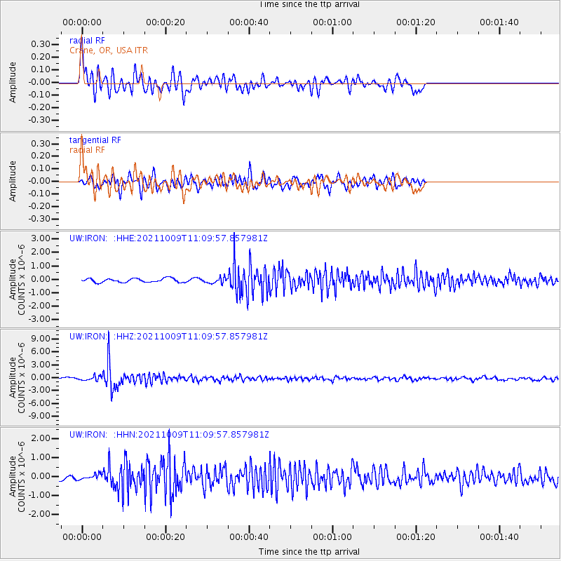
Signal To Noise
| Channel | StoN | STA | LTA |
| UW:IRON: :HHZ:20211009T11:09:57.857981Z | 2.544226 | 4.982993E-7 | 1.9585497E-7 |
| UW:IRON: :HHN:20211009T11:09:57.857981Z | 1.1350156 | 1.3197614E-7 | 1.1627693E-7 |
| UW:IRON: :HHE:20211009T11:09:57.857981Z | 1.4195039 | 2.0531023E-7 | 1.4463521E-7 |
| Arrivals |
| Ps | |
| PpPs | |
| PsPs/PpSs | |


