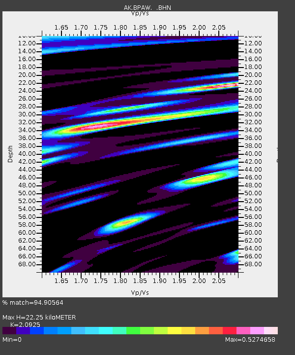
BPAW Bear Paw Mountain Broadband - Earthquake Result Viewer

Earthquake location: Near Coast Of Nicaragua
Earthquake latitude/longitude: 11.2/-86.2
Earthquake time(UTC): 2005/07/02 (183) 02:16:43 GMT
Earthquake Depth: 27 km
Earthquake Magnitude: 5.6 MB, 6.4 MS, 6.6 MW, 6.6 MW
Earthquake Catalog/Contributor: WHDF/NEIC
Network: AK Alaska Regional Network
Station: BPAW Bear Paw Mountain Broadband
Lat/Lon: 64.10 N/150.98 W
Elevation: 619 m
Distance: 69.1 deg
Az: 334.816 deg
Baz: 108.09 deg
Ray Param: 0.055861887
Estimated Moho Depth: 22.25 km
Estimated Crust Vp/Vs: 2.09
Assumed Crust Vp: 6.566 km/s
Estimated Crust Vs: 3.138 km/s
Estimated Crust Poisson's Ratio: 0.35
Radial Match: 94.90564 %
Radial Bump: 389
Transverse Match: 80.54884 %
Transverse Bump: 400
SOD ConfigId: 2475
Insert Time: 2010-03-09 13:35:04.507 +0000
GWidth: 2.5
Max Bumps: 400
Tol: 0.001

Signal To Noise

ChannelStoNSTALTA
AK:BPAW: :BHN:20050702T02:27:15.939014Z5.94416764.3162083E-77.2612494E-8
AK:BPAW: :BHE:20050702T02:27:15.939014Z13.4837238.028424E-75.9541595E-8
AK:BPAW: :BHZ:20050702T02:27:15.939014Z40.1452752.332807E-65.8109134E-8
Arrivals
Ps3.8 SECOND
PpPs10 SECOND
PsPs/PpSs14 SECOND