You are here: Home > Network List > AK - Alaska Regional Network Stations List
> Station BPAW Bear Paw Mountain Broadband > Earthquake Result Viewer
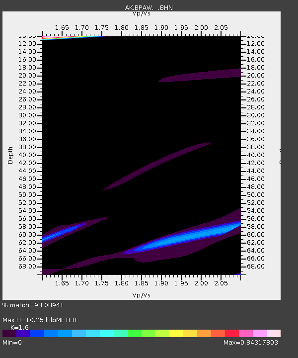
BPAW Bear Paw Mountain Broadband - Earthquake Result Viewer
| Earthquake location: |
Southeast Of Loyalty Islands |
| Earthquake latitude/longitude: |
-21.2/169.4 |
| Earthquake time(UTC): |
2007/09/28 (271) 01:50:59 GMT |
| Earthquake Depth: |
10 km |
| Earthquake Magnitude: |
5.5 MW, 5.3 MB |
| Earthquake Catalog/Contributor: |
WHDF/NEIC |
|
| Network: |
AK Alaska Regional Network |
| Station: |
BPAW Bear Paw Mountain Broadband |
| Lat/Lon: |
64.10 N/150.98 W |
| Elevation: |
619 m |
|
| Distance: |
90.5 deg |
| Az: |
16.262 deg |
| Baz: |
216.498 deg |
| Ray Param: |
0.041671727 |
| Estimated Moho Depth: |
10.25 km |
| Estimated Crust Vp/Vs: |
1.60 |
| Assumed Crust Vp: |
6.566 km/s |
| Estimated Crust Vs: |
4.104 km/s |
| Estimated Crust Poisson's Ratio: |
0.18 |
|
| Radial Match: |
93.08941 % |
| Radial Bump: |
375 |
| Transverse Match: |
48.05353 % |
| Transverse Bump: |
400 |
| SOD ConfigId: |
2564 |
| Insert Time: |
2010-03-09 13:35:16.572 +0000 |
| GWidth: |
2.5 |
| Max Bumps: |
400 |
| Tol: |
0.001 |
|

Signal To Noise
| Channel | StoN | STA | LTA |
| AK:BPAW: :BHN:20070928T02:03:29.99802Z | 1.1126865 | 1.7299949E-6 | 1.554791E-6 |
| AK:BPAW: :BHE:20070928T02:03:29.99802Z | 1.2753463 | 1.1299481E-6 | 8.859932E-7 |
| AK:BPAW: :BHZ:20070928T02:03:29.99802Z | 0.7515567 | 1.6927064E-6 | 2.252267E-6 |
| Arrivals |
| Ps | 1.0 SECOND |
| PpPs | 4.0 SECOND |
| PsPs/PpSs | 4.9 SECOND |


