You are here: Home > Network List > CI - Caltech Regional Seismic Network Stations List
> Station MPP McPhearson Peak > Earthquake Result Viewer
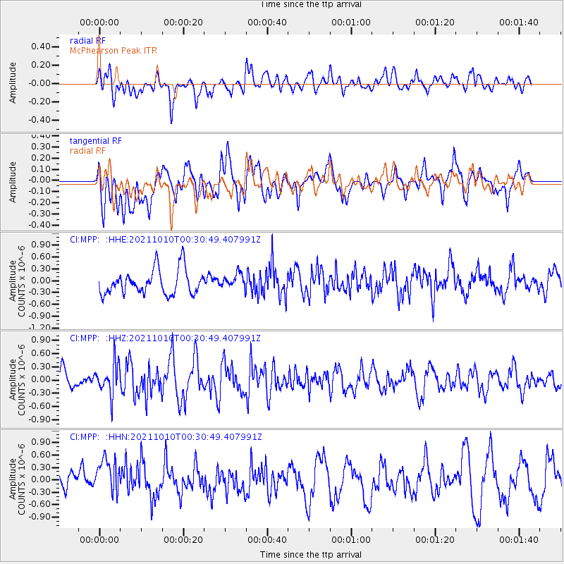
MPP McPhearson Peak - Earthquake Result Viewer
*The percent match for this event was below the threshold and hence no stack was calculated.
| Earthquake location: |
Central Peru |
| Earthquake latitude/longitude: |
-11.7/-71.7 |
| Earthquake time(UTC): |
2021/10/10 (283) 00:20:41 GMT |
| Earthquake Depth: |
13 km |
| Earthquake Magnitude: |
5.7 mww |
| Earthquake Catalog/Contributor: |
NEIC PDE/us |
|
| Network: |
CI Caltech Regional Seismic Network |
| Station: |
MPP McPhearson Peak |
| Lat/Lon: |
34.89 N/119.81 W |
| Elevation: |
1739 m |
|
| Distance: |
65.0 deg |
| Az: |
317.534 deg |
| Baz: |
126.453 deg |
| Ray Param: |
$rayparam |
*The percent match for this event was below the threshold and hence was not used in the summary stack. |
|
| Radial Match: |
55.996674 % |
| Radial Bump: |
400 |
| Transverse Match: |
57.340916 % |
| Transverse Bump: |
400 |
| SOD ConfigId: |
26497111 |
| Insert Time: |
2021-10-24 00:27:11.589 +0000 |
| GWidth: |
2.5 |
| Max Bumps: |
400 |
| Tol: |
0.001 |
|
Signal To Noise
| Channel | StoN | STA | LTA |
| CI:MPP: :HHZ:20211010T00:30:49.407991Z | 1.2681539 | 3.6408645E-7 | 2.870996E-7 |
| CI:MPP: :HHN:20211010T00:30:49.407991Z | 1.2683023 | 5.0018565E-7 | 3.9437415E-7 |
| CI:MPP: :HHE:20211010T00:30:49.407991Z | 0.59029627 | 1.8655452E-7 | 3.160354E-7 |
| Arrivals |
| Ps | |
| PpPs | |
| PsPs/PpSs | |


