You are here: Home > Network List > IW - Intermountain West Stations List
> Station MOOW Moose Ponds, Wyoming, USA > Earthquake Result Viewer
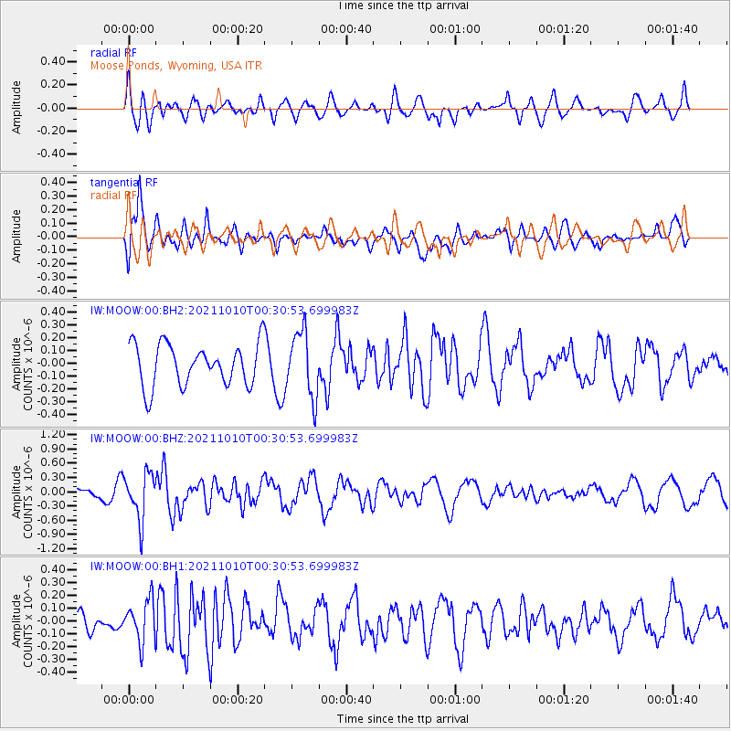
MOOW Moose Ponds, Wyoming, USA - Earthquake Result Viewer
*The percent match for this event was below the threshold and hence no stack was calculated.
| Earthquake location: |
Central Peru |
| Earthquake latitude/longitude: |
-11.7/-71.7 |
| Earthquake time(UTC): |
2021/10/10 (283) 00:20:41 GMT |
| Earthquake Depth: |
13 km |
| Earthquake Magnitude: |
5.7 mww |
| Earthquake Catalog/Contributor: |
NEIC PDE/us |
|
| Network: |
IW Intermountain West |
| Station: |
MOOW Moose Ponds, Wyoming, USA |
| Lat/Lon: |
43.75 N/110.74 W |
| Elevation: |
2128 m |
|
| Distance: |
65.7 deg |
| Az: |
329.939 deg |
| Baz: |
137.394 deg |
| Ray Param: |
$rayparam |
*The percent match for this event was below the threshold and hence was not used in the summary stack. |
|
| Radial Match: |
70.18606 % |
| Radial Bump: |
400 |
| Transverse Match: |
68.88146 % |
| Transverse Bump: |
400 |
| SOD ConfigId: |
26497111 |
| Insert Time: |
2021-10-24 00:32:08.681 +0000 |
| GWidth: |
2.5 |
| Max Bumps: |
400 |
| Tol: |
0.001 |
|
Signal To Noise
| Channel | StoN | STA | LTA |
| IW:MOOW:00:BHZ:20211010T00:30:53.699983Z | 3.524183 | 4.977736E-7 | 1.412451E-7 |
| IW:MOOW:00:BH1:20211010T00:30:53.699983Z | 2.2312558 | 1.6313587E-7 | 7.311392E-8 |
| IW:MOOW:00:BH2:20211010T00:30:53.699983Z | 1.5869011 | 2.5743327E-7 | 1.622239E-7 |
| Arrivals |
| Ps | |
| PpPs | |
| PsPs/PpSs | |


