You are here: Home > Network List > AV - Alaska Volcano Observatory Stations List
> Station KAVE Katnai Ventifact, Alaska > Earthquake Result Viewer
KAVE Katnai Ventifact, Alaska - Earthquake Result Viewer
*The percent match for this event was below the threshold and hence no stack was calculated.
| Earthquake location: |
Hawaii |
| Earthquake latitude/longitude: |
18.8/-155.5 |
| Earthquake time(UTC): |
2021/10/10 (283) 21:48:36 GMT |
| Earthquake Depth: |
35 km |
| Earthquake Magnitude: |
6.2 Ml |
| Earthquake Catalog/Contributor: |
NEIC PDE/hv |
|
| Network: |
AV Alaska Volcano Observatory |
| Station: |
KAVE Katnai Ventifact, Alaska |
| Lat/Lon: |
58.20 N/155.02 W |
| Elevation: |
702 m |
|
| Distance: |
39.3 deg |
| Az: |
0.421 deg |
| Baz: |
180.753 deg |
| Ray Param: |
$rayparam |
*The percent match for this event was below the threshold and hence was not used in the summary stack. |
|
| Radial Match: |
79.3702 % |
| Radial Bump: |
400 |
| Transverse Match: |
74.131065 % |
| Transverse Bump: |
400 |
| SOD ConfigId: |
26497111 |
| Insert Time: |
2021-10-24 21:55:52.485 +0000 |
| GWidth: |
2.5 |
| Max Bumps: |
400 |
| Tol: |
0.001 |
|
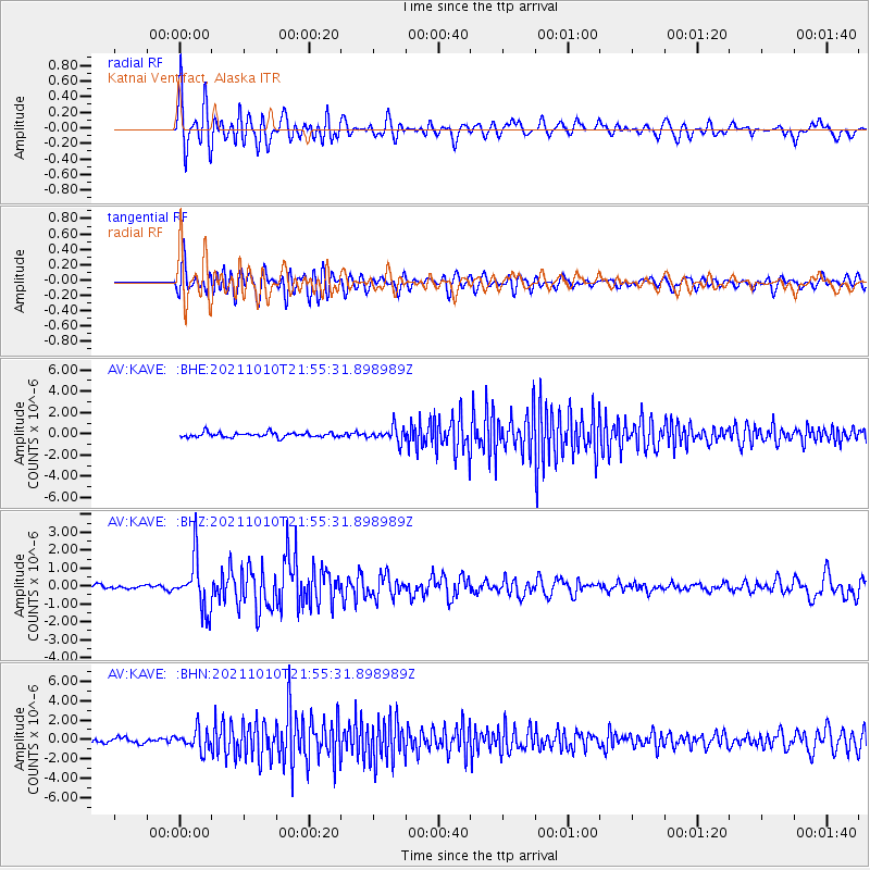
Signal To Noise
| Channel | StoN | STA | LTA |
| AV:KAVE: :BHZ:20211010T21:55:31.898989Z | 12.018935 | 1.4135918E-6 | 1.1761372E-7 |
| AV:KAVE: :BHN:20211010T21:55:31.898989Z | 4.5265226 | 1.08859E-6 | 2.4049146E-7 |
| AV:KAVE: :BHE:20211010T21:55:31.898989Z | 3.0990431 | 6.827693E-7 | 2.2031617E-7 |
| Arrivals |
| Ps | |
| PpPs | |
| PsPs/PpSs | |


