You are here: Home > Network List > AV - Alaska Volcano Observatory Stations List
> Station SPBG Barrier Glacier, Mount Spurr, Alaska > Earthquake Result Viewer
SPBG Barrier Glacier, Mount Spurr, Alaska - Earthquake Result Viewer
| Earthquake location: |
Hawaii |
| Earthquake latitude/longitude: |
18.8/-155.5 |
| Earthquake time(UTC): |
2021/10/10 (283) 21:48:36 GMT |
| Earthquake Depth: |
35 km |
| Earthquake Magnitude: |
6.2 Ml |
| Earthquake Catalog/Contributor: |
NEIC PDE/hv |
|
| Network: |
AV Alaska Volcano Observatory |
| Station: |
SPBG Barrier Glacier, Mount Spurr, Alaska |
| Lat/Lon: |
61.26 N/152.37 W |
| Elevation: |
1087 m |
|
| Distance: |
42.5 deg |
| Az: |
2.259 deg |
| Baz: |
184.43 deg |
| Ray Param: |
0.073102206 |
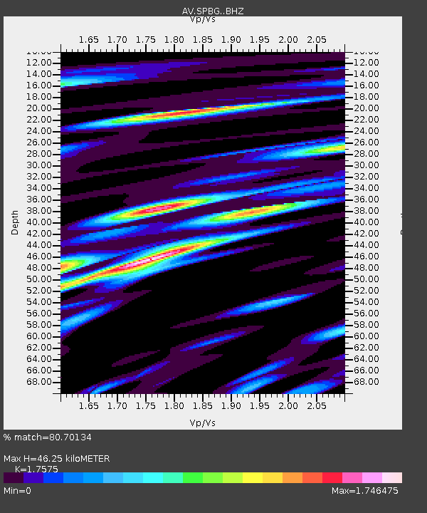
| Estimated Moho Depth: |
46.25 km |
| Estimated Crust Vp/Vs: |
1.76 |
| Assumed Crust Vp: |
6.566 km/s |
| Estimated Crust Vs: |
3.736 km/s |
| Estimated Crust Poisson's Ratio: |
0.26 |
|
| Radial Match: |
80.70134 % |
| Radial Bump: |
400 |
| Transverse Match: |
70.149086 % |
| Transverse Bump: |
400 |
| SOD ConfigId: |
26497111 |
| Insert Time: |
2021-10-24 21:56:48.199 +0000 |
| GWidth: |
2.5 |
| Max Bumps: |
400 |
| Tol: |
0.001 |
|

Signal To Noise
| Channel | StoN | STA | LTA |
| AV:SPBG: :BHZ:20211010T21:55:57.619998Z | 6.8864713 | 1.3798378E-6 | 2.0036937E-7 |
| AV:SPBG: :BHN:20211010T21:55:57.619998Z | 6.207847 | 1.1467589E-6 | 1.8472731E-7 |
| AV:SPBG: :BHE:20211010T21:55:57.619998Z | 2.079166 | 2.9941054E-7 | 1.4400511E-7 |
| Arrivals |
| Ps | 5.7 SECOND |
| PpPs | 18 SECOND |
| PsPs/PpSs | 24 SECOND |


