You are here: Home > Network List > AV - Alaska Volcano Observatory Stations List
> Station SPCG Capps Glacier, Mount Spurr, Alaska > Earthquake Result Viewer
SPCG Capps Glacier, Mount Spurr, Alaska - Earthquake Result Viewer
| Earthquake location: |
Hawaii |
| Earthquake latitude/longitude: |
18.8/-155.5 |
| Earthquake time(UTC): |
2021/10/10 (283) 21:48:36 GMT |
| Earthquake Depth: |
35 km |
| Earthquake Magnitude: |
6.2 Ml |
| Earthquake Catalog/Contributor: |
NEIC PDE/hv |
|
| Network: |
AV Alaska Volcano Observatory |
| Station: |
SPCG Capps Glacier, Mount Spurr, Alaska |
| Lat/Lon: |
61.29 N/152.02 W |
| Elevation: |
1329 m |
|
| Distance: |
42.5 deg |
| Az: |
2.505 deg |
| Baz: |
184.919 deg |
| Ray Param: |
0.0730734 |
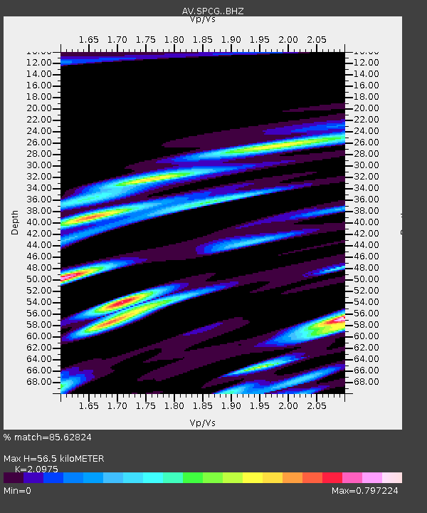
| Estimated Moho Depth: |
56.5 km |
| Estimated Crust Vp/Vs: |
2.10 |
| Assumed Crust Vp: |
6.566 km/s |
| Estimated Crust Vs: |
3.13 km/s |
| Estimated Crust Poisson's Ratio: |
0.35 |
|
| Radial Match: |
85.62824 % |
| Radial Bump: |
400 |
| Transverse Match: |
73.706894 % |
| Transverse Bump: |
400 |
| SOD ConfigId: |
26497111 |
| Insert Time: |
2021-10-24 21:56:48.877 +0000 |
| GWidth: |
2.5 |
| Max Bumps: |
400 |
| Tol: |
0.001 |
|

Signal To Noise
| Channel | StoN | STA | LTA |
| AV:SPCG: :BHZ:20211010T21:55:58.000002Z | 5.8713646 | 1.1935731E-6 | 2.0328717E-7 |
| AV:SPCG: :BHN:20211010T21:55:58.000002Z | 8.315553 | 1.0488169E-6 | 1.2612713E-7 |
| AV:SPCG: :BHE:20211010T21:55:58.000002Z | 1.7537334 | 2.0874151E-7 | 1.19026936E-7 |
| Arrivals |
| Ps | 10 SECOND |
| PpPs | 25 SECOND |
| PsPs/PpSs | 35 SECOND |


