You are here: Home > Network List > AV - Alaska Volcano Observatory Stations List
> Station SPCR Ckakachatna River, Mount Spurr, Alaska > Earthquake Result Viewer
SPCR Ckakachatna River, Mount Spurr, Alaska - Earthquake Result Viewer
*The percent match for this event was below the threshold and hence no stack was calculated.
| Earthquake location: |
Hawaii |
| Earthquake latitude/longitude: |
18.8/-155.5 |
| Earthquake time(UTC): |
2021/10/10 (283) 21:48:36 GMT |
| Earthquake Depth: |
35 km |
| Earthquake Magnitude: |
6.2 Ml |
| Earthquake Catalog/Contributor: |
NEIC PDE/hv |
|
| Network: |
AV Alaska Volcano Observatory |
| Station: |
SPCR Ckakachatna River, Mount Spurr, Alaska |
| Lat/Lon: |
61.20 N/152.21 W |
| Elevation: |
984 m |
|
| Distance: |
42.4 deg |
| Az: |
2.382 deg |
| Baz: |
184.663 deg |
| Ray Param: |
$rayparam |
*The percent match for this event was below the threshold and hence was not used in the summary stack. |
|
| Radial Match: |
66.974205 % |
| Radial Bump: |
400 |
| Transverse Match: |
65.21459 % |
| Transverse Bump: |
400 |
| SOD ConfigId: |
26497111 |
| Insert Time: |
2021-10-24 21:56:53.779 +0000 |
| GWidth: |
2.5 |
| Max Bumps: |
400 |
| Tol: |
0.001 |
|
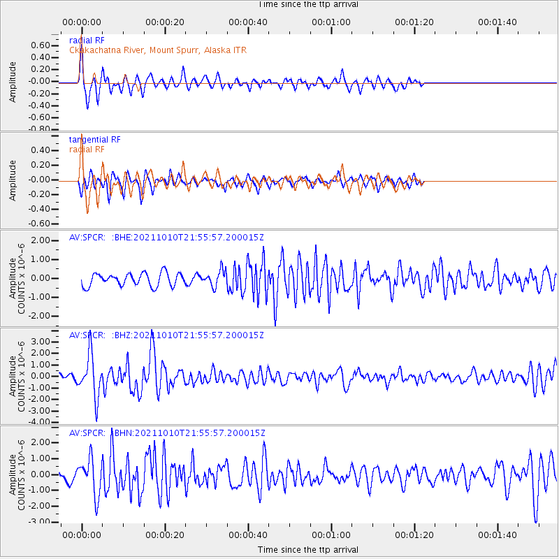
Signal To Noise
| Channel | StoN | STA | LTA |
| AV:SPCR: :BHZ:20211010T21:55:57.200015Z | 6.0040874 | 1.8719252E-6 | 3.1177515E-7 |
| AV:SPCR: :BHN:20211010T21:55:57.200015Z | 3.9322615 | 1.1684406E-6 | 2.9714215E-7 |
| AV:SPCR: :BHE:20211010T21:55:57.200015Z | 1.2675583 | 4.2969447E-7 | 3.3899383E-7 |
| Arrivals |
| Ps | |
| PpPs | |
| PsPs/PpSs | |


