You are here: Home > Network List > AZ - ANZA Regional Network Stations List
> Station SMER AZ.SMER > Earthquake Result Viewer
SMER AZ.SMER - Earthquake Result Viewer
*The percent match for this event was below the threshold and hence no stack was calculated.
| Earthquake location: |
Hawaii |
| Earthquake latitude/longitude: |
18.8/-155.5 |
| Earthquake time(UTC): |
2021/10/10 (283) 21:48:36 GMT |
| Earthquake Depth: |
35 km |
| Earthquake Magnitude: |
6.2 Ml |
| Earthquake Catalog/Contributor: |
NEIC PDE/hv |
|
| Network: |
AZ ANZA Regional Network |
| Station: |
SMER AZ.SMER |
| Lat/Lon: |
33.46 N/117.17 W |
| Elevation: |
355 m |
|
| Distance: |
37.2 deg |
| Az: |
59.175 deg |
| Baz: |
256.648 deg |
| Ray Param: |
$rayparam |
*The percent match for this event was below the threshold and hence was not used in the summary stack. |
|
| Radial Match: |
74.63088 % |
| Radial Bump: |
400 |
| Transverse Match: |
52.858997 % |
| Transverse Bump: |
400 |
| SOD ConfigId: |
26497111 |
| Insert Time: |
2021-10-24 21:57:28.124 +0000 |
| GWidth: |
2.5 |
| Max Bumps: |
400 |
| Tol: |
0.001 |
|
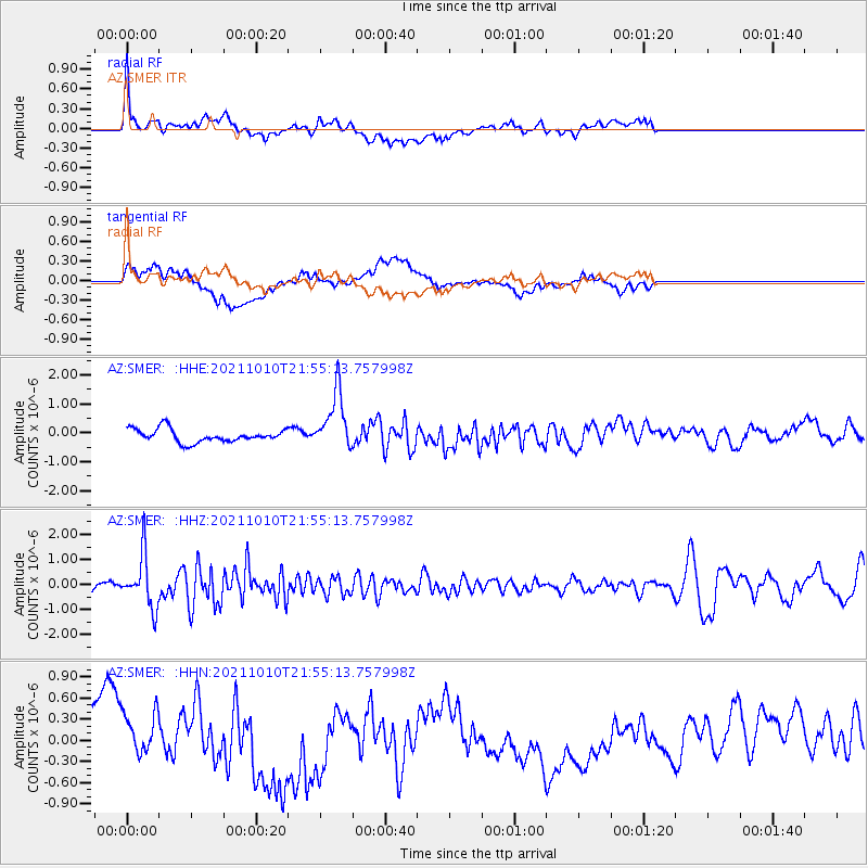
Signal To Noise
| Channel | StoN | STA | LTA |
| AZ:SMER: :HHZ:20211010T21:55:13.757998Z | 5.814305 | 1.0422849E-6 | 1.7926217E-7 |
| AZ:SMER: :HHN:20211010T21:55:13.757998Z | 0.7922739 | 4.2293675E-7 | 5.338265E-7 |
| AZ:SMER: :HHE:20211010T21:55:13.757998Z | 4.421005 | 9.996713E-7 | 2.261186E-7 |
| Arrivals |
| Ps | |
| PpPs | |
| PsPs/PpSs | |


