You are here: Home > Network List > CI - Caltech Regional Seismic Network Stations List
> Station CIA CIA, Avalon Catalina Island, CA, USA > Earthquake Result Viewer
CIA CIA, Avalon Catalina Island, CA, USA - Earthquake Result Viewer
*The percent match for this event was below the threshold and hence no stack was calculated.
| Earthquake location: |
Hawaii |
| Earthquake latitude/longitude: |
18.8/-155.5 |
| Earthquake time(UTC): |
2021/10/10 (283) 21:48:36 GMT |
| Earthquake Depth: |
35 km |
| Earthquake Magnitude: |
6.2 Ml |
| Earthquake Catalog/Contributor: |
NEIC PDE/hv |
|
| Network: |
CI Caltech Regional Seismic Network |
| Station: |
CIA CIA, Avalon Catalina Island, CA, USA |
| Lat/Lon: |
33.40 N/118.41 W |
| Elevation: |
467 m |
|
| Distance: |
36.1 deg |
| Az: |
58.85 deg |
| Baz: |
255.705 deg |
| Ray Param: |
$rayparam |
*The percent match for this event was below the threshold and hence was not used in the summary stack. |
|
| Radial Match: |
66.202 % |
| Radial Bump: |
335 |
| Transverse Match: |
55.250565 % |
| Transverse Bump: |
400 |
| SOD ConfigId: |
26497111 |
| Insert Time: |
2021-10-24 22:00:12.626 +0000 |
| GWidth: |
2.5 |
| Max Bumps: |
400 |
| Tol: |
0.001 |
|
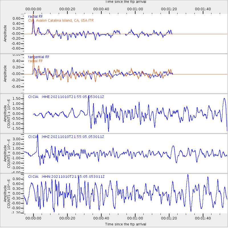
Signal To Noise
| Channel | StoN | STA | LTA |
| CI:CIA: :HHZ:20211010T21:55:05.053011Z | 5.2461596 | 1.385278E-6 | 2.6405564E-7 |
| CI:CIA: :HHN:20211010T21:55:05.053011Z | 1.9497863 | 4.951728E-7 | 2.539626E-7 |
| CI:CIA: :HHE:20211010T21:55:05.053011Z | 3.4729407 | 7.0219517E-7 | 2.0219036E-7 |
| Arrivals |
| Ps | |
| PpPs | |
| PsPs/PpSs | |


