You are here: Home > Network List > CI - Caltech Regional Seismic Network Stations List
> Station MPM Manuel Prospect Mine, California, USA > Earthquake Result Viewer
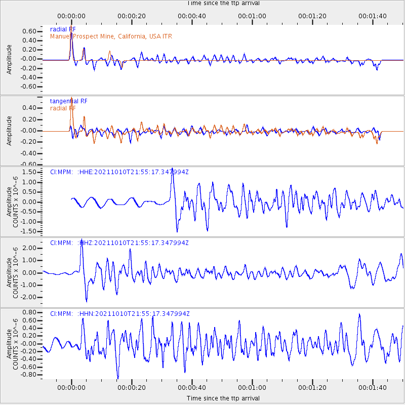
MPM Manuel Prospect Mine, California, USA - Earthquake Result Viewer
*The percent match for this event was below the threshold and hence no stack was calculated.
| Earthquake location: |
Hawaii |
| Earthquake latitude/longitude: |
18.8/-155.5 |
| Earthquake time(UTC): |
2021/10/10 (283) 21:48:36 GMT |
| Earthquake Depth: |
35 km |
| Earthquake Magnitude: |
6.2 Ml |
| Earthquake Catalog/Contributor: |
NEIC PDE/hv |
|
| Network: |
CI Caltech Regional Seismic Network |
| Station: |
MPM Manuel Prospect Mine, California, USA |
| Lat/Lon: |
36.06 N/117.49 W |
| Elevation: |
185 m |
|
| Distance: |
37.6 deg |
| Az: |
54.937 deg |
| Baz: |
253.098 deg |
| Ray Param: |
$rayparam |
*The percent match for this event was below the threshold and hence was not used in the summary stack. |
|
| Radial Match: |
75.89702 % |
| Radial Bump: |
348 |
| Transverse Match: |
56.77315 % |
| Transverse Bump: |
400 |
| SOD ConfigId: |
26497111 |
| Insert Time: |
2021-10-24 22:00:49.693 +0000 |
| GWidth: |
2.5 |
| Max Bumps: |
400 |
| Tol: |
0.001 |
|
Signal To Noise
| Channel | StoN | STA | LTA |
| CI:MPM: :HHZ:20211010T21:55:17.347994Z | 8.184279 | 9.867458E-7 | 1.20566E-7 |
| CI:MPM: :HHN:20211010T21:55:17.347994Z | 2.0268233 | 2.3144108E-7 | 1.1418908E-7 |
| CI:MPM: :HHE:20211010T21:55:17.347994Z | 3.9466176 | 6.2492455E-7 | 1.5834433E-7 |
| Arrivals |
| Ps | |
| PpPs | |
| PsPs/PpSs | |


