You are here: Home > Network List > CI - Caltech Regional Seismic Network Stations List
> Station SHO Shoshone, CA, USA > Earthquake Result Viewer
SHO Shoshone, CA, USA - Earthquake Result Viewer

| Earthquake location: |
Hawaii |
| Earthquake latitude/longitude: |
18.8/-155.5 |
| Earthquake time(UTC): |
2021/10/10 (283) 21:48:36 GMT |
| Earthquake Depth: |
35 km |
| Earthquake Magnitude: |
6.2 Ml |
| Earthquake Catalog/Contributor: |
NEIC PDE/hv |
|
| Network: |
CI Caltech Regional Seismic Network |
| Station: |
SHO Shoshone, CA, USA |
| Lat/Lon: |
35.90 N/116.28 W |
| Elevation: |
451 m |
|
| Distance: |
38.5 deg |
| Az: |
55.631 deg |
| Baz: |
254.355 deg |
| Ray Param: |
0.07549065 |
| Estimated Moho Depth: |
19.75 km |
| Estimated Crust Vp/Vs: |
2.10 |
| Assumed Crust Vp: |
6.276 km/s |
| Estimated Crust Vs: |
2.992 km/s |
| Estimated Crust Poisson's Ratio: |
0.35 |
|
| Radial Match: |
89.70184 % |
| Radial Bump: |
400 |
| Transverse Match: |
81.457214 % |
| Transverse Bump: |
400 |
| SOD ConfigId: |
26497111 |
| Insert Time: |
2021-10-24 22:01:18.272 +0000 |
| GWidth: |
2.5 |
| Max Bumps: |
400 |
| Tol: |
0.001 |
|
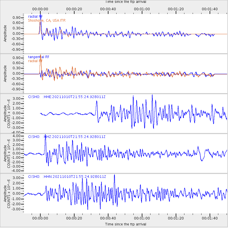
Signal To Noise
| Channel | StoN | STA | LTA |
| CI:SHO: :HHZ:20211010T21:55:24.928011Z | 12.180569 | 1.4713106E-6 | 1.2079161E-7 |
| CI:SHO: :HHN:20211010T21:55:24.928011Z | 3.9972434 | 5.7333364E-7 | 1.4343226E-7 |
| CI:SHO: :HHE:20211010T21:55:24.928011Z | 7.07509 | 1.033675E-6 | 1.461006E-7 |
| Arrivals |
| Ps | 3.7 SECOND |
| PpPs | 9.2 SECOND |
| PsPs/PpSs | 13 SECOND |


