You are here: Home > Network List > CI - Caltech Regional Seismic Network Stations List
> Station TIN Tinemaha, Big Pine, CA, USA > Earthquake Result Viewer
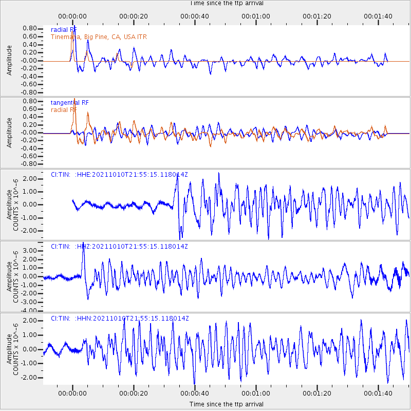
TIN Tinemaha, Big Pine, CA, USA - Earthquake Result Viewer
*The percent match for this event was below the threshold and hence no stack was calculated.
| Earthquake location: |
Hawaii |
| Earthquake latitude/longitude: |
18.8/-155.5 |
| Earthquake time(UTC): |
2021/10/10 (283) 21:48:36 GMT |
| Earthquake Depth: |
35 km |
| Earthquake Magnitude: |
6.2 Ml |
| Earthquake Catalog/Contributor: |
NEIC PDE/hv |
|
| Network: |
CI Caltech Regional Seismic Network |
| Station: |
TIN Tinemaha, Big Pine, CA, USA |
| Lat/Lon: |
37.05 N/118.23 W |
| Elevation: |
1197 m |
|
| Distance: |
37.3 deg |
| Az: |
53.08 deg |
| Baz: |
251.185 deg |
| Ray Param: |
$rayparam |
*The percent match for this event was below the threshold and hence was not used in the summary stack. |
|
| Radial Match: |
78.21862 % |
| Radial Bump: |
400 |
| Transverse Match: |
62.603737 % |
| Transverse Bump: |
400 |
| SOD ConfigId: |
26497111 |
| Insert Time: |
2021-10-24 22:01:29.598 +0000 |
| GWidth: |
2.5 |
| Max Bumps: |
400 |
| Tol: |
0.001 |
|
Signal To Noise
| Channel | StoN | STA | LTA |
| CI:TIN: :HHZ:20211010T21:55:15.118014Z | 10.67902 | 1.293796E-6 | 1.2115306E-7 |
| CI:TIN: :HHN:20211010T21:55:15.118014Z | 1.4555446 | 3.2707203E-7 | 2.2470768E-7 |
| CI:TIN: :HHE:20211010T21:55:15.118014Z | 5.0427604 | 8.134183E-7 | 1.6130419E-7 |
| Arrivals |
| Ps | |
| PpPs | |
| PsPs/PpSs | |


