You are here: Home > Network List > CI - Caltech Regional Seismic Network Stations List
> Station VES Vestal, Richgrove, CA, USA > Earthquake Result Viewer
VES Vestal, Richgrove, CA, USA - Earthquake Result Viewer
| Earthquake location: |
Hawaii |
| Earthquake latitude/longitude: |
18.8/-155.5 |
| Earthquake time(UTC): |
2021/10/10 (283) 21:48:36 GMT |
| Earthquake Depth: |
35 km |
| Earthquake Magnitude: |
6.2 Ml |
| Earthquake Catalog/Contributor: |
NEIC PDE/hv |
|
| Network: |
CI Caltech Regional Seismic Network |
| Station: |
VES Vestal, Richgrove, CA, USA |
| Lat/Lon: |
35.84 N/119.08 W |
| Elevation: |
154 m |
|
| Distance: |
36.3 deg |
| Az: |
54.633 deg |
| Baz: |
251.923 deg |
| Ray Param: |
0.07672535 |
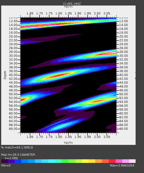
| Estimated Moho Depth: |
28.0 km |
| Estimated Crust Vp/Vs: |
2.10 |
| Assumed Crust Vp: |
6.1 km/s |
| Estimated Crust Vs: |
2.912 km/s |
| Estimated Crust Poisson's Ratio: |
0.35 |
|
| Radial Match: |
84.138916 % |
| Radial Bump: |
318 |
| Transverse Match: |
63.715076 % |
| Transverse Bump: |
400 |
| SOD ConfigId: |
26497111 |
| Insert Time: |
2021-10-24 22:01:33.683 +0000 |
| GWidth: |
2.5 |
| Max Bumps: |
400 |
| Tol: |
0.001 |
|
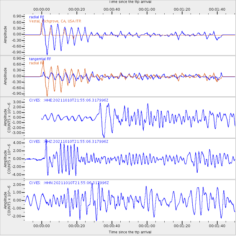
Signal To Noise
| Channel | StoN | STA | LTA |
| CI:VES: :HHZ:20211010T21:55:06.317996Z | 17.477755 | 2.0120203E-6 | 1.1511893E-7 |
| CI:VES: :HHN:20211010T21:55:06.317996Z | 1.4377077 | 4.6109344E-7 | 3.2071432E-7 |
| CI:VES: :HHE:20211010T21:55:06.317996Z | 3.566605 | 1.3221004E-6 | 3.7068875E-7 |
| Arrivals |
| Ps | 5.3 SECOND |
| PpPs | 13 SECOND |
| PsPs/PpSs | 19 SECOND |


