You are here: Home > Network List > GS - US Geological Survey Networks Stations List
> Station DEC06 Boomer > Earthquake Result Viewer
DEC06 Boomer - Earthquake Result Viewer
*The percent match for this event was below the threshold and hence no stack was calculated.
| Earthquake location: |
Hawaii |
| Earthquake latitude/longitude: |
18.8/-155.5 |
| Earthquake time(UTC): |
2021/10/10 (283) 21:48:36 GMT |
| Earthquake Depth: |
35 km |
| Earthquake Magnitude: |
6.2 Ml |
| Earthquake Catalog/Contributor: |
NEIC PDE/hv |
|
| Network: |
GS US Geological Survey Networks |
| Station: |
DEC06 Boomer |
| Lat/Lon: |
39.90 N/88.95 W |
| Elevation: |
215 m |
|
| Distance: |
60.4 deg |
| Az: |
54.31 deg |
| Baz: |
270.407 deg |
| Ray Param: |
$rayparam |
*The percent match for this event was below the threshold and hence was not used in the summary stack. |
|
| Radial Match: |
65.690285 % |
| Radial Bump: |
400 |
| Transverse Match: |
66.49627 % |
| Transverse Bump: |
400 |
| SOD ConfigId: |
26497111 |
| Insert Time: |
2021-10-24 22:05:51.633 +0000 |
| GWidth: |
2.5 |
| Max Bumps: |
400 |
| Tol: |
0.001 |
|
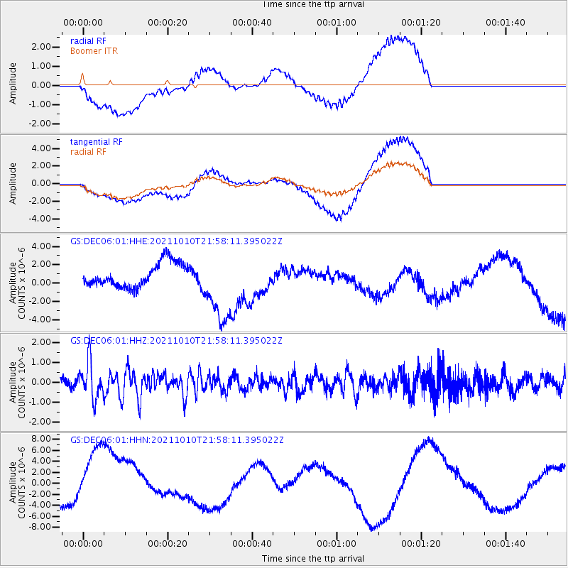
Signal To Noise
| Channel | StoN | STA | LTA |
| GS:DEC06:01:HHZ:20211010T21:58:11.395022Z | 4.959179 | 9.2606365E-7 | 1.8673728E-7 |
| GS:DEC06:01:HHN:20211010T21:58:11.395022Z | 1.8811063 | 5.8805113E-6 | 3.126092E-6 |
| GS:DEC06:01:HHE:20211010T21:58:11.395022Z | 3.044601 | 3.9575893E-6 | 1.2998713E-6 |
| Arrivals |
| Ps | |
| PpPs | |
| PsPs/PpSs | |


