You are here: Home > Network List > NE - New England Seismic Network Stations List
> Station EMMW Machias, ME, USA > Earthquake Result Viewer
EMMW Machias, ME, USA - Earthquake Result Viewer
*The percent match for this event was below the threshold and hence no stack was calculated.
| Earthquake location: |
Hawaii |
| Earthquake latitude/longitude: |
18.8/-155.5 |
| Earthquake time(UTC): |
2021/10/10 (283) 21:48:36 GMT |
| Earthquake Depth: |
35 km |
| Earthquake Magnitude: |
6.2 Ml |
| Earthquake Catalog/Contributor: |
NEIC PDE/hv |
|
| Network: |
NE New England Seismic Network |
| Station: |
EMMW Machias, ME, USA |
| Lat/Lon: |
44.71 N/67.46 W |
| Elevation: |
35 m |
|
| Distance: |
75.7 deg |
| Az: |
47.354 deg |
| Baz: |
282.293 deg |
| Ray Param: |
$rayparam |
*The percent match for this event was below the threshold and hence was not used in the summary stack. |
|
| Radial Match: |
70.40126 % |
| Radial Bump: |
400 |
| Transverse Match: |
62.368076 % |
| Transverse Bump: |
370 |
| SOD ConfigId: |
26497111 |
| Insert Time: |
2021-10-24 22:10:43.836 +0000 |
| GWidth: |
2.5 |
| Max Bumps: |
400 |
| Tol: |
0.001 |
|
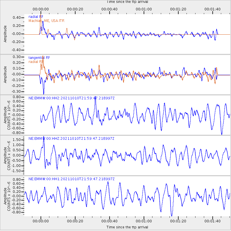
Signal To Noise
| Channel | StoN | STA | LTA |
| NE:EMMW:00:HHZ:20211010T21:59:47.218997Z | 2.1278212 | 8.1479965E-7 | 3.8292674E-7 |
| NE:EMMW:00:HH1:20211010T21:59:47.218997Z | 1.1082331 | 2.0880782E-7 | 1.8841507E-7 |
| NE:EMMW:00:HH2:20211010T21:59:47.218997Z | 1.2083328 | 3.220677E-7 | 2.665389E-7 |
| Arrivals |
| Ps | |
| PpPs | |
| PsPs/PpSs | |


