You are here: Home > Network List > NN - Western Great Basin/Eastern Sierra Nevada Stations List
> Station CTC N. Tahoe City Carnelian Bay > Earthquake Result Viewer
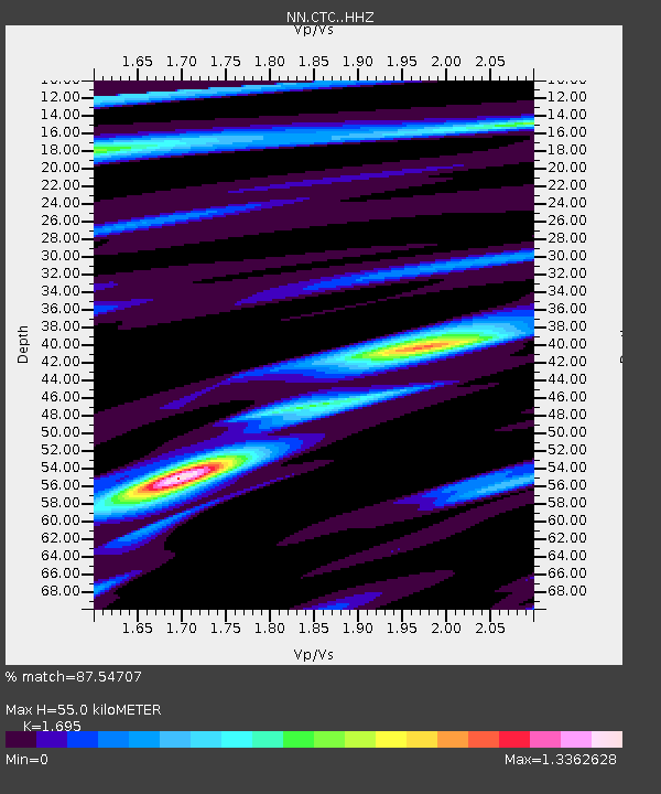
CTC N. Tahoe City Carnelian Bay - Earthquake Result Viewer
| Earthquake location: |
Hawaii |
| Earthquake latitude/longitude: |
18.8/-155.5 |
| Earthquake time(UTC): |
2021/10/10 (283) 21:48:36 GMT |
| Earthquake Depth: |
35 km |
| Earthquake Magnitude: |
6.2 Ml |
| Earthquake Catalog/Contributor: |
NEIC PDE/hv |
|
| Network: |
NN Western Great Basin/Eastern Sierra Nevada |
| Station: |
CTC N. Tahoe City Carnelian Bay |
| Lat/Lon: |
39.21 N/120.13 W |
| Elevation: |
2147 m |
|
| Distance: |
36.7 deg |
| Az: |
48.854 deg |
| Baz: |
246.644 deg |
| Ray Param: |
0.076496564 |
| Estimated Moho Depth: |
55.0 km |
| Estimated Crust Vp/Vs: |
1.70 |
| Assumed Crust Vp: |
6.597 km/s |
| Estimated Crust Vs: |
3.892 km/s |
| Estimated Crust Poisson's Ratio: |
0.23 |
|
| Radial Match: |
87.54707 % |
| Radial Bump: |
326 |
| Transverse Match: |
65.13933 % |
| Transverse Bump: |
400 |
| SOD ConfigId: |
26497111 |
| Insert Time: |
2021-10-24 22:11:18.556 +0000 |
| GWidth: |
2.5 |
| Max Bumps: |
400 |
| Tol: |
0.001 |
|

Signal To Noise
| Channel | StoN | STA | LTA |
| NN:CTC: :HHZ:20211010T21:55:09.847994Z | 7.4558043 | 8.976549E-7 | 1.2039679E-7 |
| NN:CTC: :HHN:20211010T21:55:09.847994Z | 3.3811278 | 4.0947606E-7 | 1.2110635E-7 |
| NN:CTC: :HHE:20211010T21:55:09.847994Z | 2.950894 | 5.7618774E-7 | 1.952587E-7 |
| Arrivals |
| Ps | 6.3 SECOND |
| PpPs | 21 SECOND |
| PsPs/PpSs | 27 SECOND |


