You are here: Home > Network List > TX - Texas Seismological Network Stations List
> Station WTFS Witchita Falls > Earthquake Result Viewer
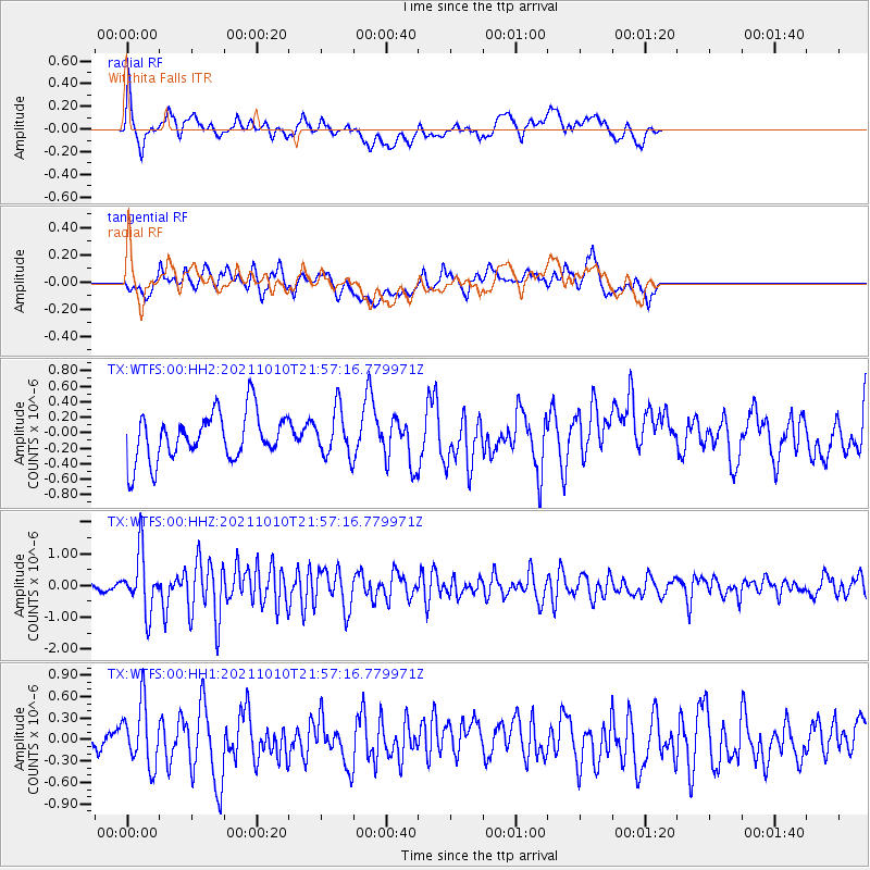
WTFS Witchita Falls - Earthquake Result Viewer
*The percent match for this event was below the threshold and hence no stack was calculated.
| Earthquake location: |
Hawaii |
| Earthquake latitude/longitude: |
18.8/-155.5 |
| Earthquake time(UTC): |
2021/10/10 (283) 21:48:36 GMT |
| Earthquake Depth: |
35 km |
| Earthquake Magnitude: |
6.2 Ml |
| Earthquake Catalog/Contributor: |
NEIC PDE/hv |
|
| Network: |
TX Texas Seismological Network |
| Station: |
WTFS Witchita Falls |
| Lat/Lon: |
33.77 N/98.46 W |
| Elevation: |
277 m |
|
| Distance: |
52.7 deg |
| Az: |
61.552 deg |
| Baz: |
268.718 deg |
| Ray Param: |
$rayparam |
*The percent match for this event was below the threshold and hence was not used in the summary stack. |
|
| Radial Match: |
67.02064 % |
| Radial Bump: |
400 |
| Transverse Match: |
58.83026 % |
| Transverse Bump: |
400 |
| SOD ConfigId: |
26497111 |
| Insert Time: |
2021-10-24 22:18:37.678 +0000 |
| GWidth: |
2.5 |
| Max Bumps: |
400 |
| Tol: |
0.001 |
|
Signal To Noise
| Channel | StoN | STA | LTA |
| TX:WTFS:00:HHZ:20211010T21:57:16.779971Z | 7.201483 | 9.170465E-7 | 1.2734135E-7 |
| TX:WTFS:00:HH1:20211010T21:57:16.779971Z | 1.8553339 | 4.2391346E-7 | 2.2848366E-7 |
| TX:WTFS:00:HH2:20211010T21:57:16.779971Z | 0.97038275 | 2.9663107E-7 | 3.0568458E-7 |
| Arrivals |
| Ps | |
| PpPs | |
| PsPs/PpSs | |


