You are here: Home > Network List > US - United States National Seismic Network Stations List
> Station HAWA Hanford, Washington, USA > Earthquake Result Viewer
HAWA Hanford, Washington, USA - Earthquake Result Viewer
*The percent match for this event was below the threshold and hence no stack was calculated.
| Earthquake location: |
Hawaii |
| Earthquake latitude/longitude: |
18.8/-155.5 |
| Earthquake time(UTC): |
2021/10/10 (283) 21:48:36 GMT |
| Earthquake Depth: |
35 km |
| Earthquake Magnitude: |
6.2 Ml |
| Earthquake Catalog/Contributor: |
NEIC PDE/hv |
|
| Network: |
US United States National Seismic Network |
| Station: |
HAWA Hanford, Washington, USA |
| Lat/Lon: |
46.39 N/119.53 W |
| Elevation: |
364 m |
|
| Distance: |
40.4 deg |
| Az: |
38.902 deg |
| Baz: |
239.251 deg |
| Ray Param: |
$rayparam |
*The percent match for this event was below the threshold and hence was not used in the summary stack. |
|
| Radial Match: |
63.287434 % |
| Radial Bump: |
400 |
| Transverse Match: |
58.478397 % |
| Transverse Bump: |
400 |
| SOD ConfigId: |
26497111 |
| Insert Time: |
2021-10-24 22:20:13.449 +0000 |
| GWidth: |
2.5 |
| Max Bumps: |
400 |
| Tol: |
0.001 |
|
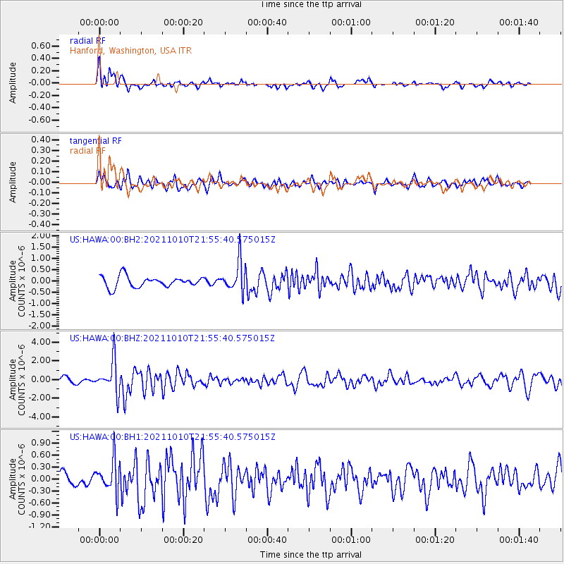
Signal To Noise
| Channel | StoN | STA | LTA |
| US:HAWA:00:BHZ:20211010T21:55:40.575015Z | 7.4809866 | 1.785109E-6 | 2.3861946E-7 |
| US:HAWA:00:BH1:20211010T21:55:40.575015Z | 2.0918646 | 4.1670904E-7 | 1.992046E-7 |
| US:HAWA:00:BH2:20211010T21:55:40.575015Z | 2.8183682 | 6.821656E-7 | 2.4204277E-7 |
| Arrivals |
| Ps | |
| PpPs | |
| PsPs/PpSs | |


