You are here: Home > Network List > US - United States National Seismic Network Stations List
> Station LAO LASA Array, Montana, USA > Earthquake Result Viewer
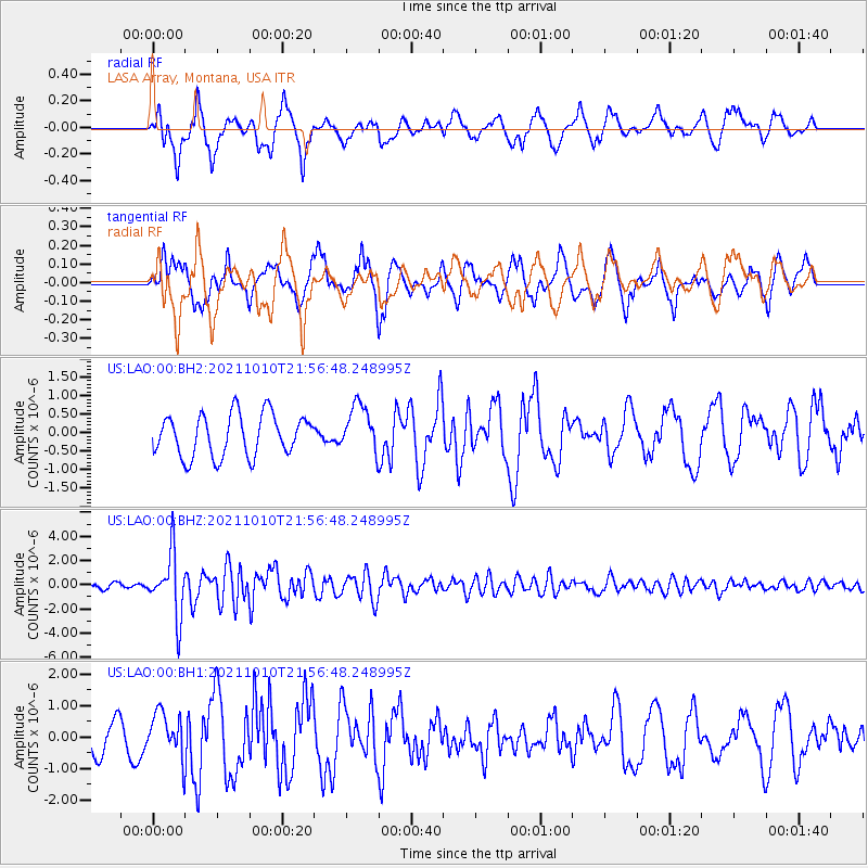
LAO LASA Array, Montana, USA - Earthquake Result Viewer
*The percent match for this event was below the threshold and hence no stack was calculated.
| Earthquake location: |
Hawaii |
| Earthquake latitude/longitude: |
18.8/-155.5 |
| Earthquake time(UTC): |
2021/10/10 (283) 21:48:36 GMT |
| Earthquake Depth: |
35 km |
| Earthquake Magnitude: |
6.2 Ml |
| Earthquake Catalog/Contributor: |
NEIC PDE/hv |
|
| Network: |
US United States National Seismic Network |
| Station: |
LAO LASA Array, Montana, USA |
| Lat/Lon: |
46.69 N/106.22 W |
| Elevation: |
902 m |
|
| Distance: |
48.9 deg |
| Az: |
43.862 deg |
| Baz: |
252.442 deg |
| Ray Param: |
$rayparam |
*The percent match for this event was below the threshold and hence was not used in the summary stack. |
|
| Radial Match: |
76.49225 % |
| Radial Bump: |
400 |
| Transverse Match: |
79.123955 % |
| Transverse Bump: |
400 |
| SOD ConfigId: |
26497111 |
| Insert Time: |
2021-10-24 22:20:25.342 +0000 |
| GWidth: |
2.5 |
| Max Bumps: |
400 |
| Tol: |
0.001 |
|
Signal To Noise
| Channel | StoN | STA | LTA |
| US:LAO:00:BHZ:20211010T21:56:48.248995Z | 10.599257 | 2.5322672E-6 | 2.3890988E-7 |
| US:LAO:00:BH1:20211010T21:56:48.248995Z | 1.8199209 | 7.2127585E-7 | 3.9632263E-7 |
| US:LAO:00:BH2:20211010T21:56:48.248995Z | 1.142179 | 6.4298206E-7 | 5.6294334E-7 |
| Arrivals |
| Ps | |
| PpPs | |
| PsPs/PpSs | |


