You are here: Home > Network List > AK - Alaska Regional Network Stations List
> Station UNV Unalaska Valley > Earthquake Result Viewer
UNV Unalaska Valley - Earthquake Result Viewer
| Earthquake location: |
Kermadec Islands Region |
| Earthquake latitude/longitude: |
-31.5/-178.8 |
| Earthquake time(UTC): |
2009/05/16 (136) 00:53:52 GMT |
| Earthquake Depth: |
55 km |
| Earthquake Magnitude: |
6.1 MB, 6.5 MW, 6.3 MW |
| Earthquake Catalog/Contributor: |
WHDF/NEIC |
|
| Network: |
AK Alaska Regional Network |
| Station: |
UNV Unalaska Valley |
| Lat/Lon: |
53.85 N/166.50 W |
| Elevation: |
67 m |
|
| Distance: |
85.7 deg |
| Az: |
7.267 deg |
| Baz: |
190.504 deg |
| Ray Param: |
0.044496674 |
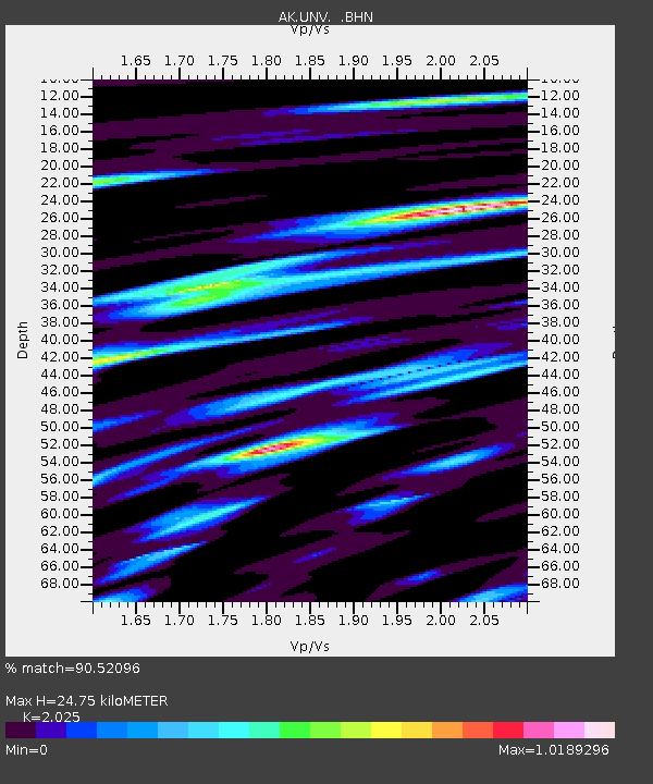
| Estimated Moho Depth: |
24.75 km |
| Estimated Crust Vp/Vs: |
2.03 |
| Assumed Crust Vp: |
3.943 km/s |
| Estimated Crust Vs: |
1.947 km/s |
| Estimated Crust Poisson's Ratio: |
0.34 |
|
| Radial Match: |
90.52096 % |
| Radial Bump: |
400 |
| Transverse Match: |
91.27408 % |
| Transverse Bump: |
400 |
| SOD ConfigId: |
2760 |
| Insert Time: |
2010-03-09 13:39:48.226 +0000 |
| GWidth: |
2.5 |
| Max Bumps: |
400 |
| Tol: |
0.001 |
|

Signal To Noise
| Channel | StoN | STA | LTA |
| AK:UNV: :BHN:20090516T01:05:54.479014Z | 18.184809 | 2.8422915E-6 | 1.5630032E-7 |
| AK:UNV: :BHE:20090516T01:05:54.479014Z | 8.460506 | 1.0789819E-6 | 1.275316E-7 |
| AK:UNV: :BHZ:20090516T01:05:54.479014Z | 2.7884781 | 4.4069404E-7 | 1.5804106E-7 |
| Arrivals |
| Ps | 6.5 SECOND |
| PpPs | 19 SECOND |
| PsPs/PpSs | 25 SECOND |


