You are here: Home > Network List > UW - Pacific Northwest Regional Seismic Network Stations List
> Station EPH2 Ephrata, WA, USA > Earthquake Result Viewer
EPH2 Ephrata, WA, USA - Earthquake Result Viewer
| Earthquake location: |
Hawaii |
| Earthquake latitude/longitude: |
18.8/-155.5 |
| Earthquake time(UTC): |
2021/10/10 (283) 21:48:36 GMT |
| Earthquake Depth: |
35 km |
| Earthquake Magnitude: |
6.2 Ml |
| Earthquake Catalog/Contributor: |
NEIC PDE/hv |
|
| Network: |
UW Pacific Northwest Regional Seismic Network |
| Station: |
EPH2 Ephrata, WA, USA |
| Lat/Lon: |
47.37 N/119.61 W |
| Elevation: |
690 m |
|
| Distance: |
40.8 deg |
| Az: |
37.574 deg |
| Baz: |
238.185 deg |
| Ray Param: |
0.074095756 |
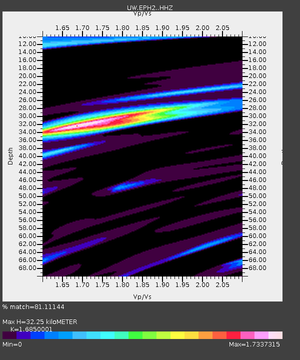
| Estimated Moho Depth: |
32.25 km |
| Estimated Crust Vp/Vs: |
1.69 |
| Assumed Crust Vp: |
6.419 km/s |
| Estimated Crust Vs: |
3.81 km/s |
| Estimated Crust Poisson's Ratio: |
0.23 |
|
| Radial Match: |
81.11144 % |
| Radial Bump: |
383 |
| Transverse Match: |
73.58703 % |
| Transverse Bump: |
374 |
| SOD ConfigId: |
26497111 |
| Insert Time: |
2021-10-24 22:21:37.502 +0000 |
| GWidth: |
2.5 |
| Max Bumps: |
400 |
| Tol: |
0.001 |
|

Signal To Noise
| Channel | StoN | STA | LTA |
| UW:EPH2: :HHZ:20211010T21:55:44.380007Z | 13.111466 | 2.5323677E-6 | 1.9314145E-7 |
| UW:EPH2: :HHN:20211010T21:55:44.380007Z | 3.6111958 | 4.9819613E-7 | 1.3795876E-7 |
| UW:EPH2: :HHE:20211010T21:55:44.380007Z | 7.1916 | 9.071403E-7 | 1.2613887E-7 |
| Arrivals |
| Ps | 3.7 SECOND |
| PpPs | 13 SECOND |
| PsPs/PpSs | 16 SECOND |


