You are here: Home > Network List > UW - Pacific Northwest Regional Seismic Network Stations List
> Station IRON Crane, OR, USA > Earthquake Result Viewer
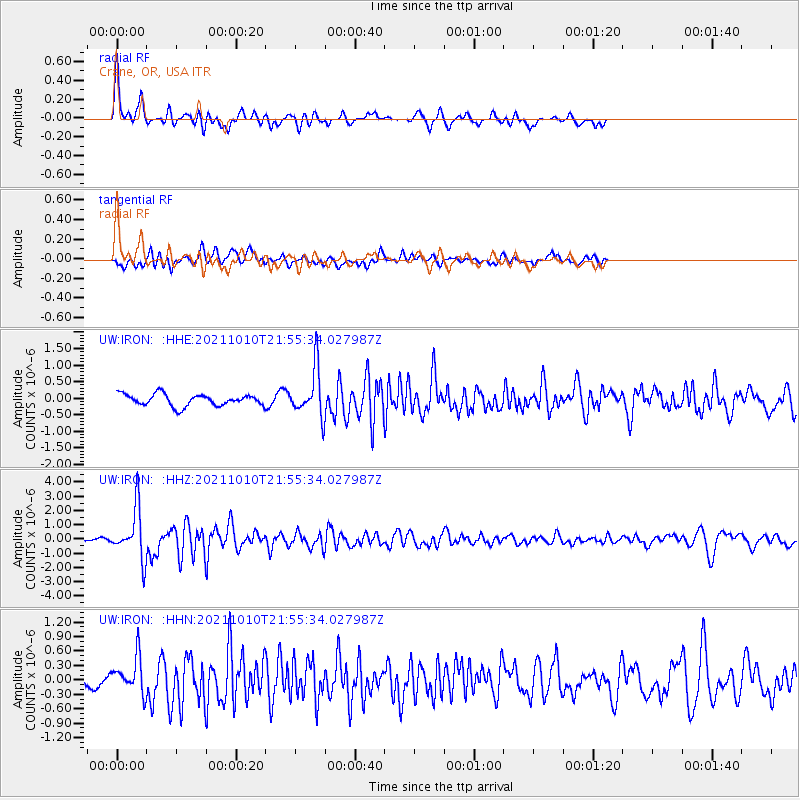
IRON Crane, OR, USA - Earthquake Result Viewer
*The percent match for this event was below the threshold and hence no stack was calculated.
| Earthquake location: |
Hawaii |
| Earthquake latitude/longitude: |
18.8/-155.5 |
| Earthquake time(UTC): |
2021/10/10 (283) 21:48:36 GMT |
| Earthquake Depth: |
35 km |
| Earthquake Magnitude: |
6.2 Ml |
| Earthquake Catalog/Contributor: |
NEIC PDE/hv |
|
| Network: |
UW Pacific Northwest Regional Seismic Network |
| Station: |
IRON Crane, OR, USA |
| Lat/Lon: |
43.36 N/118.47 W |
| Elevation: |
1226 m |
|
| Distance: |
39.6 deg |
| Az: |
43.611 deg |
| Baz: |
243.604 deg |
| Ray Param: |
$rayparam |
*The percent match for this event was below the threshold and hence was not used in the summary stack. |
|
| Radial Match: |
74.84525 % |
| Radial Bump: |
400 |
| Transverse Match: |
59.859207 % |
| Transverse Bump: |
400 |
| SOD ConfigId: |
26497111 |
| Insert Time: |
2021-10-24 22:21:55.953 +0000 |
| GWidth: |
2.5 |
| Max Bumps: |
400 |
| Tol: |
0.001 |
|
Signal To Noise
| Channel | StoN | STA | LTA |
| UW:IRON: :HHZ:20211010T21:55:34.027987Z | 9.52062 | 1.766207E-6 | 1.8551385E-7 |
| UW:IRON: :HHN:20211010T21:55:34.027987Z | 2.7993846 | 3.8892793E-7 | 1.3893337E-7 |
| UW:IRON: :HHE:20211010T21:55:34.027987Z | 4.0152984 | 7.11002E-7 | 1.7707326E-7 |
| Arrivals |
| Ps | |
| PpPs | |
| PsPs/PpSs | |


